Friday, June 26, 2015

Today I Trek on Tractor Tire Tracks

Today I plan a randonnée to the fortified city of Ternand, just beyond Létra.  Inhabitation there dates back to Roman times, and several fortifications were built there around the 12th century: including a castle, a church, a belltower and a fortified farm.  The randonnée map also indicates an impressive viewpoint.  Even though it is a walkable distance away (about 5-6km), we decide to drive there so that we could explore the area’s attractions more on foot, rather than just do an out-and-back.  Unfortunately, as we walk out the door of the gite, we find that the camionette is not available, so we make a last-minute decision to head back up the hills on the opposite side of the River Azergues.

We select the hill that we failed to access before, mainly because we can clearly see the roads from this angle, and map out a simple loop as we head down Le Cocon towards Le Cret.  We plan for an approximately 6.5km randonnée.  It ends up being an 11km randonnee with approximately 250m elevation drop from the gite into the Azergues River valley, and another 250m up the other side.


We take our usual route to Chamelet on the road.  Then we cross the River Azergues at the train station.   On the other side of the railroad tracks, there is a complicated intersection. The rightmost road heads North to Bergeron, the road straight ahead follows the Ruisseau (creek) des Brosses heading West, and two roads heading to the left (South).  We head up Montée de la Grange.  It is the right-hand fork of the two roads heading left.  (Clear as mud, right?)  If we were to take the other road heading left (the left-most fork of the two left roads?), we would quickly end up in the town’s recycling depot.  


We stay on Montée de la Grange as it heads up the hill, then crosses the face of the hill horizontally.  The name changes to La Grange then Vaurion, but we just keep on following it straight up, without taking any further forks.  
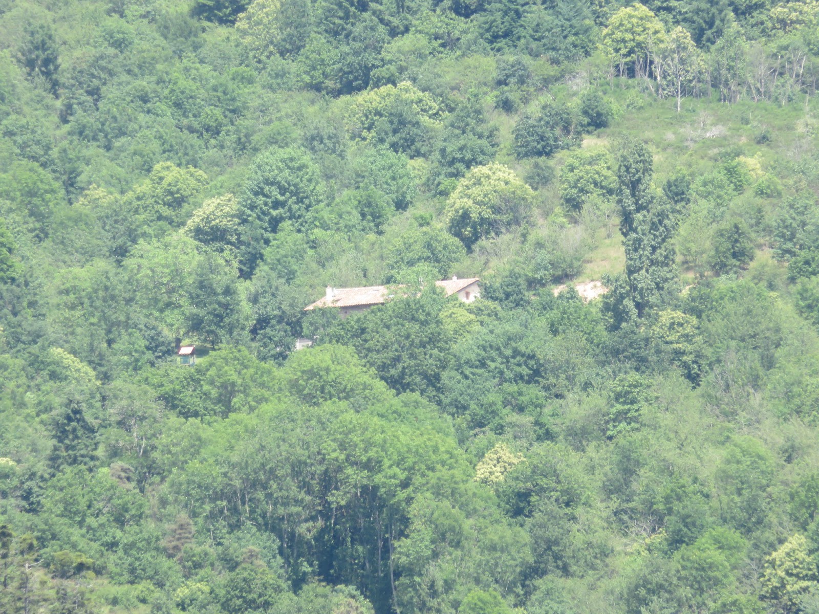
Looking back towards Chamelet to our North, we are rewarded with a view of our gite!  Zooming in with the camera, I can even see the skylight in the roof and the children’s playhouse in the yard.   Looking to the East, I see the forest where we got lost the other day.  I can even see the path we walked on the other side of the forest.  However, the path through the forest is concealed by the trees.


Further up the road, there is a sign stating “Les Vignes,” but it is positioned between two roads that both look like they head in the correct direction.  However, we notice that the left fork has a sign indicating “dead end,” so we take the right fork, which basically keeps us going straight ahead. I guess the vineyards visible just ahead on the road should have been a clue.


We pass briefly into the forest, then run alongside it to Le Peigneaux, where we encounter an unmarked randonnée signpost at a fork, pointing the way South to Les Brosses… and strangely, also to Chamelet??  I walk to the other side of the signpost to see what lies along the other fork:  La Font Davy!!!  This is the other end of the long-lost path we could not find the other day!  I briefly consider walking it to the other hillface, just to see where it comes out.  A quick calculation of our mileage today makes me decide to leave it, and continue back along our planned route.  Colin needs to be back at the gite for his “meeting time” within the next hour and a half, so there just would not be enough time to go the other way.


We follow the paved road South, around a farm in a tight U.  At the bottom of the U, we pass through a tiny grove of trees, and are surprised by a large buzzard that takes flight from the trees right above our heads.


Just beyond the farm, there is a fork in the road, with a little white electrical hut.  We hear a strange buzzing noise, and at first think it might be the hut, but quickly realize that the field to our left is hosting a bee farm.  I run up on the hill beside it and am rewarded with a stunning view of the countryside.  (As an aside:  Why are the rear of these electrical huts always half-buried??  Does it have something to do with cooling??)  We take the smaller, more decrepit road to the right of the hut, which almost immediately starts to descend the hill.


Soon we can see the Les Brosses randonnée signpost, which directs us off the road and onto a grassy path.  From the markings on the map, I expect a fabulous viewpoint, but here, the view is limited, and the foreground is filled with a giant pile of manure.  Not quite the view I was hoping for.  ;)   In protest, my camera battery promptly dies.


As the path continues to drop steeply, we are suddenly surrounded with dozens of butterflies!  They are hard to see in the photos… perhaps partially because these are taken with a cell phone.  I play with the butterflies but it ends up just looking like we are doing tai chi together.  Lol. 


The path continues to drop steeply, first past a creepy looking artificially planted forest, then past vineyards.  All the trees in the forest are perfectly straight and evenly spaced.  The bottom braches have all been trimmed off and create a blanket of dead brush on the forest floor.  It seems like this forest could be used as a film set for some dark fairy tale.  


After the forest, we pass by vineyards, and can see the modern wasteland that is Bergeron down to our left.  The views toward Chamelet are spectacular, but I have to really watch my footing.  We are both slipping and sliding down the steep rocky path. Colin wonders who uses and maintains this road.  In the ruts of the road, I notice tractor tire tracks, and spend the next ten minutes trying to say that five times fast.


We pass a cell phone tower, then step back onto Vaurion/La Grange/Montée de la Grange, at the intersection with the “Les Vignes” signpost.  As we descend on the road, I am still trying to say “tractor tire tracks,” and I notice a tractor slowly chugging its way towards us up Montée de la Grange.  I amuse myself by starting adding “T” words to my alliteration: “I am trekking on tractor tire tracks…”  By the time the tractor reaches us, we are standing beside a second tractor… “TWO tractors!” I crow with glee, and continue adding “T” words to the phrase: “Today I trekked on two tire tractor tracks!”  To my surprise, instead of rolling his eyes at me, Colin starts trying to say it too.


We pass an elderly man working in his garden, and I have a flashback to my childhood, watching my grandpa in his garden.  I wish I had gotten a photo.  Down near the bottom of the hill, some interesting looking sheep are having a good nosh.


We cross the River Azergues into downtown Chamelet. Heading up Montee des Paves, we pass some kind of cat convention, and pet one nice cat that got separated from the flock… herd?... what is a group of cats called anyway??...  


To the Internets!  Apparently, a group of cats is called a clowder or a glaring.  Those both sound very sinister.  Only one is potentially glaring at us.  The rest seem pretty mellow.  I’ve decided:  I’m going to call it a flock.  Lol. 


Wednesday, June 24, 2015

An Excellent Randonnée in Oingt

Today we map out a walk back in the region of Sainte Paule (see top left area of map below).  We decide to park in Oingt (go ahead… make your best guess on how to say Oingt, then check here). After walking through Oingt, we will walk down to Saint-Laurent d’Oingt to the church I saw perched on the hillside yesterday. Then we’ll walk back on a trail parallel to Le Ruisseau Vervuis for a while, then cut over back to Oingt.  It’s an 8km hike with an elevation change (both down and up) of 275m


We park the camionnette at the Stade Joannes Minot, and are quickly rewarded with a randonnée signpost that very helpfully indicates “All Directions” with an arrow.  I guess we can’t go wrong by following it.  ;)


We walk down Rue Chemin du Stade and within 0.1km we find the La Guillardière signpost, again pointing us in “All Directions,” but also fortunately to Place de Presberg, our next destination.  We turn right onto Montée de la Guillardière.  The road is filled with lovely flowers, and we can soon see the town of Oingt ahead of us, with its iconic 18m tower.  The signpost at Place Presberg points us towards Prony and Saint-Laurent d’Oingt.


We walk down Route du Bois d’Oingt past La Porte du Nizy, a 13th century gate was at one time a drawbridge entrance to the battlements.  Now it is the only part of the old ramparts still standing.


A randonnée sign painted on a tree tells us to turn left off the road… past some very golden stones and onto a grassy path.  (Yes, look closely, that's the grassy path on the right of the photo.) This is apparently Chemin des Peupliers. The purpose of this path is to avoid walking all the way to the corner and making a sharp right onto Route de Saint-Laurent d’Oingt.


We are soon at the Prony signpost, in front of the Tuilerie de Prony, a tile factory.  The sign tells us to continue straight on the same road, past the factory, towards Dalbepierre and St Laurent d’Oingt.  We somehow miss the Dalbepierre signpost, but googlemaps gets us onto Rue Dalbepierre (left fork).  We hang a left, and as we walk, we can see Saint-Laurent d’Oingt in the distance, and beyond that, our destination church on the hill.


As we walk, Rue Dalbepierre changes its name to Le Gonet.  As we pass through the countryside, we walk among vineyards and grassy fields, speckled with the occasional house.  This gorgeous one, pictured below, is actually a gite called L'Orée du Paradis.  It looks amazing!!


A little farther, we find ourselves at the Le Bussy signpost.  Here we turn right and head towards “Le Bourg” of Saint-Laurent d’Oingt.  The grassy path drops down so abruptly, it seems to simply drop off a cliff.  However, it is just an optical illusion: once we get closer to the crest, we can see it is actually a gentle downward slope.  The grassy path exits onto the paved Chemin du Lavoir, which heads directly up to the school (visible in background at right in the "optical illusion photo"). I enjoy the little songbirds darting in and out of the orchard to our left, including one bright yellow bird that I never manage to capture on film. Instead, you can enjoy this bird that I did manage to capture on film.  ;)


We arrive into the Bourg of Saint-Laurent d’Oingt in front of a very impressive building on Rue du 14 Juillet.  To the right, we see some public toilets, set into the stone wall.  It appears we can go left or right to get around the building and head up to the church.  We go right, up Montée de Priuré. We soon see some signage pointing us up Rue Nicholas Chervin. There is a restaurant on our right, named... what else?... Le Saint-Laurent Restaurant Bar.  We consider buying an ice cream from its storefront, but then decide against it. 


On Rue Nicholas Chervin, Les Escaliers de la Chapelle come up quickly, and we head up a long staircase that opens unceremoniously into a grassy field.  There, ahead of us, is the church!  


After climbing up to the church, we look back at Oingt (on the far ridge), which looks impressively far away.  Did we really just come from there?  A sign offers us much information about the different kinds of grape vines in the Beaujolais region, including the ways they are pruned.  We had been wondering why some vines were lower to the ground and spread out horizontally, while others were trimmed more like trees, with tall trunks rising a couple of feet before branching out. Apparently, the two styles used in the Beaujolais region are called “Gobelet” and “Guyot.”


You might be surprised to learn that Oingt is not traditionally a wine-making region.  In fact, centuries ago, when Oingt was at its height, only about 10% of the land held vineyards.  Most of the vineyards that now blanket the countryside date from the 20th century.

The wine that we non-specialists call “Beaujolais” is not a type of grape, but refers to the location where the wine is made.  In fact, “Beaujolais wine” can be further divided into 12 different appellations (specific sub-areas that are legally allowed to label their wine by their location). The Beaujolais grape varietal is called Gamay.  Beaujolais is sometimes not given as much respect as some of the other types of wine in France, because Gamay grapes produce a light easy-drinking wine.  I admit, I used to always forgo Gamay for the heavier or “full-bodied” wines like Cabernet Sauvignon, Zinfandel, and Syrah, but as my palate is growing, I am starting to give more credit to the often-neglected wines like the Gamay.  Sometimes it’s nice to have an easy-drinking “food wine” that doesn’t knock you out after a glass or two.  Plus, I’ve noticed that not all Beaujolais wines are created equal, and some can definitely hold their own as a sipping wine.  

I digress. The church is closed (natch), but I manage to take a neat photo of the interior through the keyhole.  This is a strange skill I have been gaining while in France.  Inside, I can see a lovely statue in front of a stained glass window.  


Beside the church is a well-kept cemetery. We walk down the paved road between the church and the cemetery, and into some of the surrounding vineyards.  The map indicates there should be a second church around here somewhere.  We circle around the vineyards, including one that appears to be a graveyard for grapevines, and watch a hawk hunt in the adjacent field. We never find a second church.  We return to the road, and head towards the Mont Joli signpost.


As we stand at the Mont Joli signpost, pondering which path to choose to return to Oingt, a kindly young fellow stops his bike and asks us if we need directions.  We decide to head to the Ruisseau Vervuis, to see if we can actually see the creek itself (as opposed to yesterday, where we got close but didn’t get to see the creek).  As we head down the rocky path towards the creek, we can see the steep rocky path we took yesterday, running down from Sainte Paule to the creek on the hill ahead to the far left.  Its golden stones stand out in stark relief against the green of the vineyards.


We pass through a tiny forest, then along the bottom of a vineyard.  It's very picturesque.  We can see some kind of stone bluffs ahead of us, and wonder if it’s a man-made wall or a quarry.  I hope the trail gets close to the bluffs... it would be neat to walk along there. 


Reaching the Ruisseau de Vervius signpost, we can hear -- but not see -- the creek.  We decide to follow the sound, turn left, and quickly stumble upon a very tiny creek teeming with very large blue dragonflies.  The dragonflies are much more impressive than the creek itself. 


Then we turn around 180 degrees and return to the signpost, and take the path uphill towards Polluis. It’s a quick 40m rise in elevation within 200m of distance.  :p   For the first time today, we are hot and sweaty.  We pass two horses, standing head to rump, very cooperatively fanning each other’s faces with their tails.   Then I spy a cute little lizard shading himself in the rock wall.  It seems we are not the only ones around here who are affected by the heat.


Between Polluis and La Garenne, we hit our only stumbling block.  The road appears to go straight on, but the real path turns to the left.  We actually head down Dalbepierre road a while before Colin says: “This doesn’t feel right,” and checks the GPS.  We backtrack and notice that there is actually a randonnée “X” on the road, indicating “wrong way.”  The correct walking path is a narrow unlabeled cement road that quickly disintegrates into gravel, with a sign that indicates “no entry except firefighters.”  It turns out, that is the Chemin de Prony.  We head into the trees, and the shade is a nice relief after our steep ascent from the creek.  Along this path, we pass the rock bluffs we had seen in the distance earlier, and realize it is a quarry.   We also pass a really neat looking “castle” that I am pretty sure is just somebody’s home.   Because in France, it seems people often live in castles. Soon we find ourselves back by the Prony tile factory and signpost, having come up the path perpendicular to the road we had walked earlier on our way to Saint-Laurent d’Oingt.


We turn left back onto Route de Saint-Laurent d’Oingt.  Then, instead of returning exactly the way we had come, we skip Chemin des Peupliers and follow Route de Saint-Laurent d’Oingt all the way to the corner where it meets Route du Bois d’Oingt.  Right after our left turn onto Route du Bois d’Oingt, Colin suggests a nameless grassy path that heads more directly up into Oingt.  We head up the path, which reminds me of the trails in Brittany: it’s barely more than a walkway behind people’s back yards.  We think of our recent hike in Les Bois Pouissons near Le Maroc, where we ended up walking into a garden party.  Fortunately, this time, we soon encounter a set of stairs that drop us at the Restaurant Creperie Les Pierres Dorees and Le Table du Donjon


Next to the restaurants is the cave au vins Duperray (Domaine d'Iconium) belonging to “the other Stephane,” but of course, today it is closed.  A stop at the wine cave is probably not a good idea right now anyway, since Colin has to soon work his evening shift.  


Turning left onto Rue Paul Causeret, Oingt’s iconic tower, “Le Donjon,” looms ahead of us.  It is the only part of the old castle of Oingt that is still standing.  We go over to see it, and find out it is only open on Sunday afternoons.  So while we don’t get to see the inside of the tower, we do have fun watching some cats and birds by the tower.


Undiscouraged, we walk on and visit the church Saint Mathieu, the oldest building in Oingt, dating to the 10th century, when Oingt was called “Iconium.”  The doors are (surprisingly) open!  Inside there is a statue of Saint Mathieu that looks uncannily like Mr. Burns.


As we stroll down Rue Paul Causeret, there is signage to tell us about parts of the castle and ramparts that are no longer in existence.  What are in existence today are many little artisanal shops and cafés, but of course… you guessed it… none are open.  We wander through some of the smaller streets of the town.  It really is quite picturesque, and earns well its place as the only town in Rhone to be among “France’s most beautiful villages.”


We finally exit to Rue Presberg through La Porte Nizy.  Since the town really seems deserted, we are quite shocked to find a couple having a coffee and croissant outside of Chez Marguerite.  On the corner is the amusing two-cart “market” I encountered with Matt and Mel.  I turn to Colin:  “Do you want any fish or cheese?”  Then I feel badly when I notice the cheese monger perk up as she spies us from across the street.  They could probably really use some customers. 


We return to the camionette via Montée de la Guillardière.  At the corner of Chemin du Stade, I am greatly amused by one young cow repeatedly headbutting another cow’s behind, and by the sweetest little white cow who seems to be eyeing me hopefully.  I seem to be a sucker for a cute white cow.  Who knew?  Lol.   I take one last look at the stunning scenery, and turn toward the car to complete today’s excellent randonnée.