Monday, March 20, 2017

Bowen Hiking 23: September Morn Beach

Jan 1, 2017

The morning's snowstorm turned into a windstorm.  It was still -6°C, but precipitation had stopped.  A Polar Bear Swim was scheduled at Bowen Bay Beach.  There was no way I was going to do that!!  xp  Especially when it meant driving cross-island in a windstorm just to *get* to it.  But it did inspire me to check out September Morn Beach, which was a lot closer to home.

I planned a 4 km round-trip walk from my house, but for the sake of this blog, I'll start in the Village, since many of you would come from there. Note that it is nearly exactly 2 km from the ferry to the beach, along the road.  Although I took Gardner Rd to Dorman Rd to Hummingbird Lane (marked in purple dots), f the weather were better, I could have just as easily taken Dorman Point Trail from Bowfest Beach (dotted maroon line), then turned off the trail at Robinson Rd, and turned left onto Hummingbird Lane. The route I did take took me up about 60m in altitude to the top of Dorman Rd, then downhill along Hummingbird Lane about 40m. Going via the trail would be shorter, but steeper.

(click on image to enlarge)

September Morn Beach was said to be named after the song of the same name by Neil Diamond. However, it seems so much more likely that it was named after the 1911 Chabas painting, since the beach was "clothing optional."  ;)

Ironically enough, the first (and nearly only) piece of early history of the area that I could find was a 1903 Government Gazette of BC, which described how a J. Douglass had applied for a logging licence to "strip" the 480-acre area (Lot 1658) of timber.  (Get it? Strip?... It's ok, insert groan here.)

In the first few decades of the 20th century, the area near the end of what is now Hummingbird Lane had also been the location of the "largest and relatively most productive mine on Bowen Island... the Bowena Mine" (source: BC Rockhounder).  In the last few years of the 19th century, four areas of Bowen Island were explored and developed for mining. Besides Bowena, the other three were the Albion copper mine (near Cates Bay) the Islander copper mine (in Galbraith Bay), and the Bonanza gold, silver, lead, zinc, and copper mine (on Mt Gardner near Bluewater).

(click map to enlarge, or see original at 

The Bowena mine extracted copper/gold ore and silver. Two adits (horizontal tunnels), one 10m and one 70m, and a 10m shaft (vertical tunnel) were dug to explore three veins. One of the veins looked really promising in test shipments, and so a 100-ton-per-day mill was built. Another mining company, the Snug Cove Copper Company, staked a claim nearby, and made a 50m tunnel towards the vein in question. However, low copper prices and inadequate equipment meant low returns for both companies. In 1920, the mine dock was destroyed in a storm, and the mine closed soon thereafter.

In the 1960s, when the neighborhoods of Queen Charlottte Heights and Valhalla were starting to be subdivided, another attempt was made to find profitable ores in the area, but it came up empty. In modern days, although many properties (including our own!) still have underground mineral rights listed on their property titles, "mineral exploration is no longer permitted on Bowen Island."  Thank goodness! We wouldn't want to have to deal with any of THIS...

The Bowena mine adits are purportedly still relatively easy to locate, but difficult to access, due to the steep and treacherous shoreline, and the fact that anything above the tideline is now private property.  As you will see, this was certainly not the day to test that report!  The weather was not at all cooperative.

However, with blue skies above, and the snowfall stopped, I was optimistic for a nice brisk walk. I bundled myself up and set out.  I was offered a ride LIFT on the way to the Village by a random passing car.  That should have been my first sign that I was crazy to be out walking in that weather!


Walking along the shoulder of Dorman Rd away from the Village, I noticed by their hoof-prints that the deer had been walking along the shoulder too!  The white car that had gotten trapped in by the snowploughs was still there, holding vigil over the empty road.


At the first turn of Dorman Rd, a man fought the wind gusts coming down the hill as I headed up, "I've walked it both ways and down is easier!" he called out, with a wink.


I smiled and laughed, turned the corner, and headed up. A small group of people were walking down towards me, with their tiny dog.  The dog looked as scared as my dog Rory was that morning, listening to the howls of some terrible monsters in the skies. 


As we passed, the wind roared again, and branches fell around us. I barely avoided being hit. A huge CRRRRRRAAAAAAACK! signaled a tree falling down in the forest next to the road.  One man in the group and I exchanged raised eyebrows, as if to say, "well, THIS was escalating quickly..."


I pulled some big branches off the road at the curve in the road right before the intersection of Dorman Rd and Hummingbird Lane. The trees were whipping around fantastically, although I couldn't seem to capture that on camera.


The road from there to the intersection was littered with branches, and more rained down the whole time I was walking.  Although all I could see were evergreens, according to Chris Corrigan"Up on Hummingbird Lane, on the crest of Dorman Point is the remnants of the Dorman family orchard, now divided throughout several private lots." 


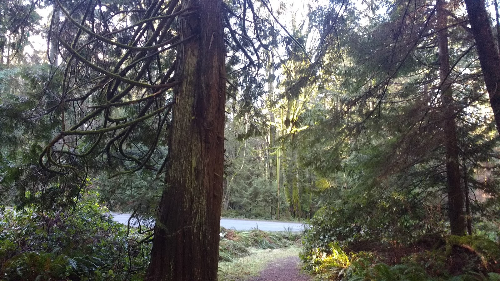
I took Hummingbird Lane, which was really just a straight ahead continuation of Dorman Rd. Just past the corner, I could see the ocean roiling through a gap in the trees. Whitecaps abounded. 


On Hummingbird Lane, big branches mixed with small windfalls. Some especially large branches had been already pulled off the road.  The road itself was like a sheet of ice. 


I tried to capture the undulating movements of this grove of bamboo, as it was frothed by the high winds: it was moving almost as if underwater.  But it just looks like I took a blurry overexposed photo. 


In the next stretch, I needed my head down to watch my feet on the ice, and up for falling branches. I alternated, while clutching my toque and reaffirming to myself that this walk wasn't such a great idea...


There were some really nice views of the ocean, along this stretch.  I even got to see a BC Ferry bobbing about in the waves (that's a big class C ferry-- probably the Langdale ferry, the Queen of Surrey. The smaller Bowen ferry sailings were soon all cancelled).


The sky was thick with what seemed like hundreds of birds, careening wildly.  Hah!  You thought was birds but was branches... Bamboozled again!


I started to wonder how much farther it was to the beach.  According to google maps, the road had already ended.  My GPS said that I was in the ocean...  :/  Clearly, neither was correct!


I continued along the road, figuring I had nothing to lose. I kept an eye out for anything resembling a "trail" on the left side of the road. Actually, it was really obvious when I did get there, as there was a cul-de-sac, with a street sign saying "end of public road" on the one side of the circle, and signs for the beach on the other side.


Behind the garbage can, a snow-covered path led steeply towards the water.


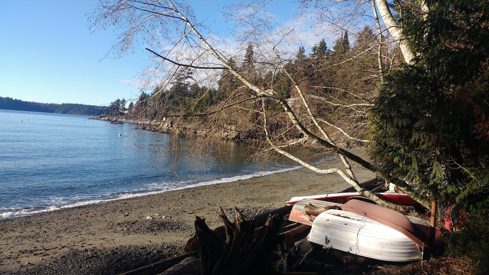
Even from that distance, I would see the waves crashing on the beach at high tide. It sure didn't look too safe. I figured I'd follow the path as long as it seemed safe. The trail was not as scary or slippery as it looked. I had firm footing all the way down.  It was surprisingly less slippery than the road!  I guessed that was because it had not been compacted by vehicles.


At the end of the trail, there was a wooden bench at the top of a set of wooden stairs leading down to the beach-level. In the distance, I could could see Wreck Beach-- the clothing optional beach at UBC in Vancouver. Well, maybe the beach itself was too far away to see, but I could see where it should have been located, on the Western-most tip of UBC.


The left side of the beach was protected by a small outcropping of rock. The right side was open to the ocean, and stretched a fair distance.  It would be great at low tide. While the waves were crashing in fast and furious on this frigid winter's day, it was going to be fantastic in the summer!!  Although I suspected that this beach would not have the vendors that made Wreck Beach even more enjoyable. Oh Lucy, what will I do without your empanadas?!?!


I was losing feeling in my fingers as I tried to get my pano function to work properly.  First the distance wasn't right, then the lighting wasn't right. It kept malfunctioning.

Then, in the midst of my struggle, a hot tub beckoned from down below... wait?! what?!   I wondered about the chances of it actually being hooked up in the summer. More likely, it would be used as a "kiddie pool."  I'd have to wait and see.


My phone must have been registering my chilly distress, and smart enough to recognize the dark red hot tub in the viewscreen, because it popped up a notification dated 4 years ago to the day:  a "remember this day" photo collage of my Woodenfish trip to China. How are those related, you ask?  let me explain.

The workshop was "in the south" of China (in Guangzhou), which usually meant tropical temperatures somewhat like Hawaii (20-25ยบC), even in winter.  However, it was not clarified that the monastery where we would be staying (the Nanhua Temple) was actually up in the mountains.  And that there would be no central heating inside the classrooms or dorms.

As a result, almost no-one packed appropriately. As temperatures dipped down near zero, we put on every piece of clothing that we brought with us, and sent workshop aides to nearby towns, in search of hot water bottles and extra fleece blankets (donated to the monastery afterwards).  Our workshop organizer looked the other way when we wore our blankets to meditation. Finally, she succumbed to pity, and arranged for a New Year's excursion to the nearby hotsprings. Since none of us had packed bathing suits, we had to purchase these beauties on-site.  XD


My warm memories were certainly not enough to stop my fingers from freezing, so I stuffed my hands back into my ski gloves, and headed back up the path to the cul-de-sac.


Soon I was back on the ultra-icy patch, playing "look-up-look-down" with the ice and flying debris.  The wind was roaring like sea lions or walruses or maybe some kind of sea lion-walrus hybrid... wait:  is that what a Liger actually is?  I might just be in over my head here...   What was I talking about again??


I made my way up Hummingbird Lane back to the intersection with Dorman Rd, and proceeded onto it.


Can you see where I cleared the road before?  No. The wind had already replaced the branches that I had cleared earlier.


The trail running beside Dorman Rd didn't look too bad. I pondered taking that route instead: maybe there would be less wind??  Just then, I head a loud BANG!! Another tree crashed in the forest to my right: a reminder that I would probably have more luck on the road than in the forest, if a tree came down.  I let it go, and stuck to the road.


On the way home from the Village, I got offered another LIFT. Where were these cars on the rest of my walk?!  I declined the offer, because I am some kind of masochist.

At home, the power kept flicking on and off.  Although our area had buried power lines, other areas of the island could easily lose power, if a tree were to fall on the lines. We decided to play it safe, and cook our soup dinner earlier than we had planned, but of course, then we didn't lose power again.  ;p

Thanks for reading.  Here's a "goofy dog" tax.


Tuesday, March 14, 2017

Bowen Hiking 22: Evergreen Part 2 (West Side and Bowen Bay Beach)

Dec 30th

After falling in love with the Evergreen Forest the day before, we went back the next day, and parked at the same place: the parking lot on Evergreen Lane, off Bowen Bay Rd.

Using the bowentrails.ca map, I plotted out a route on the West side of Evergreen. In retrospect, I should have used the map at the trail head instead, because we ended up going in the completely opposite direction than we planned. We wanted to do "The Grind" upwards, and ended up going down it instead.  We had no idea where we were at least half of the time.  lol.

(If you missed the map confusion of the day before, go back and take a look!)

So here is the walk that *I think* we ended up doing (in pink), which was maybe 4km and about 150m in elevation change (I am guestimating!).

(click on image to enlarge)

We had planned to go North up to Malkin Creek Rd, then swing around the loop to the West, and finish off with "the Grind" (marked as "steep trail" in orange on map). Somehow, we missed the turn we wanted and ended up getting to the centre of the park, then heading South again, through the "viewpoints." (I just now, after writing this entire blog, noticed that they are actually marked as "Forest Meditation Nodes," which as you will see, explains a lot.)

This time, unlike the day before, we took the correct trail head -- the one next to the stone pillars on the road. But after that, we were definitely not as well oriented as the day before. lol.


At the trail junction, we kept left/straight, and continued walking parallel to the road, following the signs "to Malkin Creek." 


Yes, my dog Rory joined us for the walk today.  He was pretty pokey. I told him so, and called him "Pokey" for most of the walk.


Where the road split into a Y, the path cut across the corner. I couldn't figure out where this was supposed to be on the map. On any map. (And if you remember, I was using four different maps.)


Where the trail exited onto the other road, I could see the trail continuing straight ahead on the other side of the road. None of this stuff seemed to be on any of the maps I was using. 


We passed a small pond, which turned out to be Maggie's Pond. I had mentioned Maggie Cumming and her contributions to the island's parklands in my blog about the Golf Course Loop Trail. Her name stood all over the island, to remember her efforts.


The trail led off into the forest. The trail signs were not helpful, saying things like "viewpoint" and "Bowen Bay."  Pretty much any of the trails could have led to those things.  We gave up trying to navigate and just followed the trail.  We would only much later figure out where we were. 


I thought this set of trees was pretty neat.  Sorry for the quality, you might have to click on the image and enlarge it. It shows maybe 10 little trees growing out of a fallen tree, suspended in the air. I wondered whether they could grow fast enough to set down roots before the tree inevitably rotted and fell.


At this point, we were not sure whether the trail went left or right.  Treefalls didn't help, as they obstructed the paths. We decided to try left, along the length of the fallen tree, up onto the top of the stone. 


It opened to a nice mossy clearing. We didn't know if it was supposed to be a viewpoint, but there was not much to be seen besides the moss and nearby trees.


We wandered around, trying to see where the path went from there. The clearing seemed to slope steeply down on all sides, with no way to get down, except how we had come. 


I tried using my GPS to figure out where we were, and got quite a shock.  Based on the little "pond" we had seen, I had thought we were up near that little "pond" showing on the upper right of the following map screenshot. Instead, we were in a  totally different area of the park!  (Turned out that the upper "pond" showing on google maps was the Community Water Supply, and Maggie's Pond was simply marked "Pond" on the trailhead map--and didn't show at all on google maps.)


I guessed incorrectly, that we must indeed be at one of the "viewpoints" labelled on the treailhead map.  We didn't know it then, but we were most likely at the "forest feature." 

We retraced our steps back off the rock and to the fork, and took the right-hand trail to move onward. 


Soon we were at another fork!  The sign on the path to the right said "to viewpoint," but, less than impressed with the last "viewpoint," Colin wanted to push onward. We took the fork towards Bowen Bay. 


Then we hit yet another fork.  "Viewpoint" proclaimed the sign.  What?!?!  Ok, it was at this point that we figured out that the first "viewpoint" (the "forest feature") never meant to be an actual viewpoint, and so Colin relented into another side-trip to check it out.


This viewpoint was... SURPRISE!  another mossy clearing.  lol. 


If I angled the camera just right, I could barely make out "something" in the water in the distance... an island? Maybe Paisley island??  Hard to say.


 Far more interesting than the "view" was the world at my feet!  So many different kinds of moss. Colin asked if I had a "moss book," to match my bird book. I didn't, but I really wished that I had, at that moment!!  :D


We headed back to the last intersection, and took the other fork. 


 You guessed it: we hit a T-intersection.  The signage said Bowen Bay to the right, and Malkin Creek to the left. As you can see, Rory was eager to check out Bowen Bay.


The trail very quickly started heading downhill. Yes, we were at "the Grind" (marked as "steep trail" in orange on the trailhead map). As the trail zig zagged down the steep incline, we passed some pretty big downed trees.  Colin took a photo of me against a root ball of one of them.  Actually, it's the one on the left in the photo below. Remember what I said about the scale of the trees in this forest?  ;)


After the Grind, we were down at road level, running parallel to Bowen Bay Rd for a bit. Apparently, there were several new roads in this area, that are not even on google maps, as evidenced by the street signs we passed. 


Then we were back into the trees. I loved the way the stump below was rotting away.  It was like art.


We ended up walking between some houses on the left and a fern-covered incline on the right. One house had a collection of tiny cabins behind it. I wondered whether they were B&B type rentals. 


The path continued in the forest, then suddenly turned to grass.


We were suddenly in a very different kind of forest! 


We saw a more elaborate parks sign, declaring this to be Malkin Creek Trail. 


The difference in the trail was striking. 


We crossed over a little stream, then seemed like we were simply standing in someone's driveway.  Where was the trail?  Where were we supposed to go??


We wandered out into the intersection. Street signs told us that we were at the corner of Malkin Creek Rd and Amelia Lane. 
  

Looking at where we had exited from the forest (where the light is, at the right side of the photo above), I thought that I would never have found that trail from this end, so I snapped a closer photo for your benefit, dear reader. To find the trail we had just been on, go down the driveway between the address numbers "1631" and "1621."


Now that we definitively knew where we were, we decided to walk down to Bowen Bay Beach and take a look. We headed downhill along Malkin Creek Rd. 


Where it intersected with Windjammer Rd, we took a left.  


The road continued downward to where it met up with Bowen Bay Rd: in all, about 41m of altitude loss over 350m.


Right at the bottom of Windjammer Rd, we saw the signage for the beach. A little trail led off the road to the right.  The beach was only a few metres away-- about the length of a short driveway.


It was quite a nice sandy beach, with a bench and porta-potty right near its entrance. Many people had their self-propelled water craft pulled up above the tide line. 


I had mentioned the history of Bowen Bay in my blog post about Cromie Trail. This beach had remained popular among the locals, especially youngsters, and even had a swimming float. 


After a quick look around, we headed back up the hill towards Evergreen.


We turned right onto Malkin Creek Rd and soon enough were back up at the intersection with Amelia Lane.


Now, I say "intersection,"  but actually Malkin Creek Rd ends in a cul-de-sac to the left, and Amelia Lane continues on to the right. But street signage makes this area easy to naviagate. 


Just then, a big raptor soared high over our heads. I thought it was an eagle or a turkey vulture, but my phone camera was unable to capture a clear shot. Both are common on Bowen Island. My guess was turkey vulture.  If it were closer, I could have given you a definitive ID. 


Not far up Amelia Lane, the trail split off to the left of the road.


It wove through the young alder trees. We could hear, and sometimes see, the creek running parallel, on our right. 


Almost 200m later, the trail opened again to the road, so we could have walked up the road to this point, if we had chosen to.  However, the trail continued on to the right. 


As we passed this junction, I snapped a photo of it.  Recognize it?  I didn't, for another few minutes...  ;)


We continued onward, along the trail to the right, and crossed over the creek we had been following. 


Suddenly, I recognized a power pole and a unique tree.  Colin laughed at me, but the tree was hard to forget--I knew I had seen it before.  How could this be?


Checking the GPS, I realized that we were indeed on a stretch of trail that we had walked the day before. The intersection that we had just passed was the trailhead with the chain that we had entered from from the road, walking in the opposite direction down Amelia Lane, the day before. 

We then arrived at a very familiar intersection: the one where with the chain, where I stood for quite a while, not being able to figure out which direction the sign "lookout" was pointing. This time, we took that very same "mystery" trail to the right. 


As we walked toward it, we realized that we were actually at a kind of T-intersection with the "road": to the right was the "yellow trail" from the trealhead map, and to the right was the "grey trail" from the trailhead map. Here's a reminder:


Finally, that intersection made sense!  This section was indeed very "road"-like, besides from the fact that it was gravel and not pavement. It was obviously being used by vehicles, which is why the trail we had just exited needed to be chained off from vehicles. 

Houses popped up left and right along this stretch, and there was even a giant red bin on the side of the road, from someone in the midst of construction. 


We arrived at an intersection with some signage. There was a clear trail sign, pointing to "viewpoint."  This must have been the HUGE viewpoint marked at the end of the "yellow trail" on the map. I tried to convince Colin to go check it out, but he wanted to head back. There was also a map of the subdivision, which turned out to be fairly valuable. 


This was the *only* map that showed the trail cutting across the Y of the road in this area. (You remember me not being able to locate it on any of my four maps?  Well, sadly, we were only maybe 50m or less away from this sign at the time.)  Anyway, the photo below shows the end of that trail, as it passed Magggie's Pond.  Suddenly, THAT part of the trail made sense too!  Ok, so to walk this section we did today, you only need 5 maps...  sigh. 


Although we saw the trail running beside the road, we decided to walk on the road itself, just for a change from the day before.  Rory suddenly perked up, and trotted down the road.  He's such a city dog.  Or maybe he remembered that we had some more beef jerky left in the truck...?  ;)


About 300m later, we were back at the parking lot. (Sorry, Rory, no drinking fountains on this road, but at least you get to ride in the truck at the end of your journey.  lol.)


After our walk, Ben came for another visit. With a small son at home, he was eager for some adult conversation... that is to say, conversations with adults, not... well, you know.  ;)   He brought us a housewarming gift of Lagavulin, and the most hilarious motion sensor light for our toilet.   (um, now that I think of it, those gifts were unrelated, I hope.)  After being activated, the light stayed on for 3 minutes, changing colors.  I absolutely loved it!!!!  Merry Christmas to me!!!


On our way to a nice sushi dinner in Village Square, we walked around Snug Cove, then up to Artisan Square along a new route (sorry, photos in the dark don't work well, and I've abandoned the practice!).  Then we watched some movies and comedy specials on our projection screen, whilst sipping our peaty peaty golden nectar and cheering each other on: "Whit's fur ye'll no go past ye."