
The Mid-Island Trail lived in that murky place between myth and legend... a fabled trail that led across the length of the island, without touching Grafton Rd or Adams Rd.
In case you didn't know, dear reader, Grafton Rd to Adams Rd is the only paved route that connects the east end of the island to the west: the only way to cross the island by car. The Trans-Island Trail (TIT) was meant to fill the gap for pedestrians; however, much of it ran along the very narrow shoulder of the very busy Grafton Rd. Not ideal. Although there was currently discussion on improving it.
I had found a single blog describing the MIT, by Charles Clapham, who had taken the bus from the ferry to Bluewater, and walked back along the trail. Here's a screenshot of the map on his blog (click on image to enlarge).

While I hadn't planned on completing the Handloggers Half, I had hoped to start on Carter Rd and go as far as Amelia Lane, or even Bowen Bay, but, as you will see, I ran out of time, and ended up turning around and hoofing it back to beat the sunset.
I figured it would be easy enough to follow Charles' instructions in reverse: he seemed to provide a lot of detail, and a map!
While the map provided on Charles' blog was not really "precise" for navigation purposes, I found that when I zoomed in far enough, Google maps seemed to show a trail matching the description in the blog. I'd use my GPS to follow that as I walked.
Set out at 12:15 pm, thinking I'd be gone maybe 3 hours. It was about 10.5 km round trip from Carter Rd to where I stopped, at the junction of Mt Gardner Trail and the trail down to Laura Rd. (The ferry was about 1 km away from where I started on Carter Rd; Artisan Square maybe 500m, so add in those distances if you want to start/end at those locations. I walked over to Artisan Square to start my hike on this day-- mostly so I could go to Artisan Eats.) As you will see, I took much longer than that, futzing around on my way out. But my return time suggested I could have easily done the blue trail on the map in 3 hours.

(click on map to enlarge)
It was -7°C, but a bright sunny day with clear blue sky. I took my phone and a spare charger, but still told my neighbor my hiking plans, "just in case."
As I headed out my street, I caught a flicker looking for suet in my neighbor's feeder. In First Nations lore, the Flicker can represent "transitions" (some people say even "death," but most often just big changes). They teach you to go with the flow of change, and be resourceful. I was going to need it, for my first big hike "off the map"!


From there, I followed Artisan Lane down to the Trans-Island Trail entrance at the bus stop on Grafton Rd, and cut through to Carter Rd via the "orange fence" trail that ran parallel to Terminal Creek.


When I could see the Children's Centre, scross Carter Rd, I turned left and followed the dirt trail along to the little bridge on Carter Rd.


The bridge crossed Terminal Creek, and the pond which supplied the gravity fed hatchery, down near the BIRD and the Knick Knack Nook on Mt Gardner Rd.


Following Carter Rd, I passed Cates Hill Chapel and the Island Pacific School.


A Raven cackled at me, overhead. That Trickster must have foreseen my wrong turn into Belterra, and was having a good laugh at my expense. ;p
I accidentally turned left at the end of the pavement of Carter Rd. This is partially because the road continued to be paved in that direction, and partially because I was looking for a left turn. This route hairpined me back behind the school and chapel and led up to a large housing complex.


Belterra was a recently completed (2015) co-housing complex set on 10 acres of land. Nearly half of that property was dedicated to the municipality as a reserve, and included walking trails. I'd definitely have to come back and explore these more.


While the trip to Belterra was an interesting diversion, I realized that I should have gone straight off the end of Carter Rd, where it turned to gravel. I retraced my steps. Following this gravel road all the way would take me down to the BIRD and the Knick Knack Nook ( I knew this because I drove it in my car one day by accident--it was a little scary!), but I knew I didn't want to go as far as Mt Gardner Rd on this day.

I was looking for a trail that led off to the left of Carter Rd. Walking along on the gravel Carter Rd, I couldn't find the trail. I kept checking Google maps, which seemed to say I was close to it. Then realized I was somehow already on it. ????

On the right, Carter Rd swung back in a hairpin towards BIRD.


It sure looked like the corner I was looking for, on Google maps, but my GPS (the blue circle with arrow) showed I was already far ahead of where I thought I should be (the red pin). I think my GPS was off. It was indeed the "left-hand trail" I was looking for. I moved along.

Shortly after that, it appeared as if the road split. One side was marked "private lane" and had street numbers and buildings, including one saying Ravenhill Farm. Ravenhill Farms was run by Peter Frinton & Carol Rob. "Peter Frinton is a long time [and politically active] resident of Bowen Island (over 40 years), living on a small farm/homestead with his partner Carol- a visual artist, avid reader, gardener, and Tai Chi instructor."


Since I was looking for a "trail," I took the grassy fork on the right. However, that "path" petered out quickly and ended in a step embankment of a creek, so I got back on the gravel road.


There was an interesting little building on the left side of the road. It reminded me of the many graineries I had seen along the Camino in Spain.

I kept following the gravel road, until I saw a "Private Property" sign, and a house up to the left. But JUST past the sign, I could see what looked like a trail leaving the road on the right.

I decided to check out out, since many public right-of-way easement trails on Bowen Island seem to begin/end in people's driveways. In these cases, while it's true that the land itself is "private property," which legitimize the placement of a "private property" sign, it's ALSO a "public trail." I discussed this phenomenon previously, here and here.
Charles' blog mentioned that the property owners didn't mind people walking on the trail, as long as they stuck to the trail. That also sounded like a right-of-way easement situation.

As I got closer, I confirmed that it was indeed the entrance to the trail, which quickly left the house and the gravel road far behind.

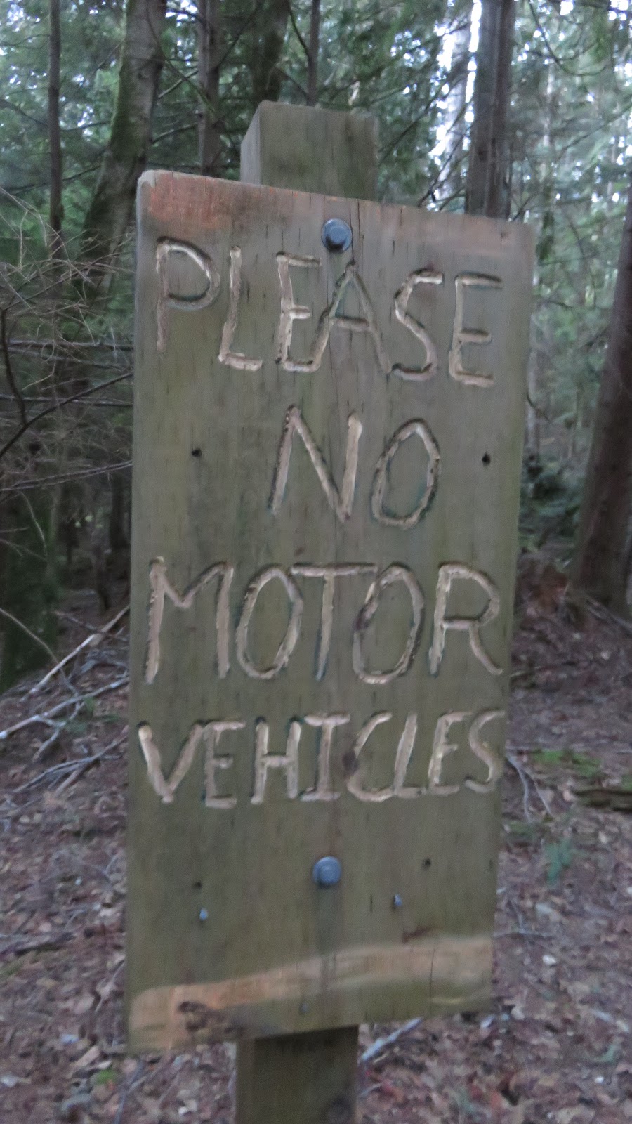
While there were no trail signs to be seen, within a very short time, I was rewarded with a fairly official looking "no motor vehicles" sign. Since this was a rule on most right-of-way trails, I decided I was on the right trail. If this was a purely private trail, why would they have need for the sign??

The path first rose up steeply, and appeared like a dry creek bed. Then it became wide and flat, as if it were the remains of an old logging road. Perhaps this was why Google maps showed it, when it didn't show so many other trails on the island? Some trees had fallen into the trail, but they were all easy to get over/under.


Then I spied a white sign on a tree far off the trail to my right. I used the camera zoom to read it: "No Trespassing. Ropes Course. Not to be used without supervision by authorized personnel." Searching around in the neighboring trees with my camera zoom, I did see some unusual-looking contraptions up high above a clearing.


A little later, a trail led off to the right, and I assumed it was the access to the ropes course area. Another small trail led off to the left, towards Grafton Rd. Was this ropes course a part of Camp Bow-Isle??? Based on the location, it was entirely possible.
Camp Bow-Isle was first built in the 1960s, and it grew to be a 200-acre summer youth camp for Christian Scientists to explore and enjoy nature together. While the lands have grown in the ensuing decades, the facilities have remained rustic, and campers sleep on tent platforms. A main lodge has a kitchen and showers, as well as electricity and a single phone. Daily activities for campers include hiking, canoeing, sailing, rock climbing, and of course... a ropes course.
Just past the ropes course area, a small patch of mud in the otherwise dry path showed me that several people and dogs had come through here recently.


The trail dipped down slightly, and there was a little cabin off in the woods to the right. I think it was just about equal to the end of Green Rd.

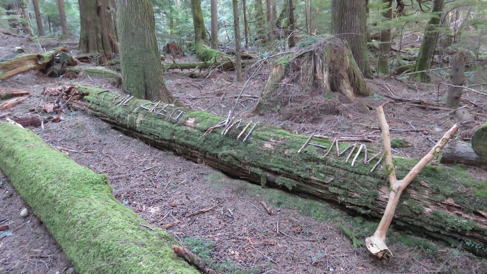
I passed the rootball of a giant fallen tree that looked like some kind of monster, about to eat me or start a rumpus.

Perhaps the names "signed" onto this log held a clue as to what the monster would do? ;) Was one of them named the "king" of the wild things?? ;)
After that, there were two large piles of trees on the path. The first was a pile of evergreens, about up to my knees.

The second was a mix of evergreen and alders. Likely, the larger evergreens had fallen on top of a grove of alders and broken them on the way down. This second pile took up a fair distance of the trail. It was trickier to navigate, but I could eventually see the trail emerging from the other side and headed for it.


There were some really cool giant stumps in this section. They were surely remnants of the logging done on Bowen Island ca. 1880-1900. This stump was acting as a nurse log to other trees.


I decided that the brush of all these windfalls would give me "cover" to finally take my near-desperate pee. I needn't have worried-- I didn't meet another soul on the entire trail.
A creek crossed the trail, and I was really unsure which way to go. Looking at Google maps and GPS, seemed like neither went towards Grafton Lake, nor followed the Google maps road. In fact, the GPS told me that the way I had just come was from the direction of Grafton Lake. Sigh. the GPS was obviously struggling, under the tree canopy. Charles' blog was no help here either: travelling in the opposite direction, he merely mentioned that after crossing Malkin Creek, the rest was "clear sailing." Did that mean take the trail that was more directly straight ahead?? DETAILS, Charles, I need more DETAILS!! XD Finally, I made my best guess to take the trail on the left/straight ahead, rather than take the trail on the right. It turned out to be the correct choice.

(click image to enlarge)
The sky was brilliant blue, and it outlined the giant maple trees covered in moss and licorice ferns.


The "trail" past this, as it were, turned into a dry creek bed (Guild Creek!). Fortunately for me, it was dry, and easy to travel.

At one point the trail diverged from the creek bed, but it ran alongside it and rejoined it shortly after. I imagined that it would be beautiful with the water running, but also really difficult to traverse that one part where Creek and trail merged.


Where the trail rejoined the creek bed, a different trail diverged off to the left. A bright white square on the ground caught my eye, and I went up to see what it was. Was it an envelope?

The first "trail sign" of this trip! It read: "To Mt Gardner Trail."

Well, I didn't want to go to Mt Gardner on this day, so I stuck to the creek bed. Both Google maps and my GPS told me to head into the Creek. Despite my earlier GPS struggles, it was now telling me that I was somehow back on the trail heading to Grafton Lake!! YES!!


After big puddle, which trail skirted, I encountered a fork in the trail as it headed steeply down.
Charles' blog mentioned two paths leading up from Grafton Lake that met at the same point. The one further east was supposed to be a little easier; the one further west, steeper. I wondered whether these were the two trails.


I finally went right, following the more major trail and the GPS, which was pointing more directly onto the Google maps route.

It was rough and steep down. A ways down, a short tail linked the two trails that had forked previously. I peeked over onto the other trail, and it seemed that it continued wet, like a creek, after this junction.
I stuck to the trail I was already on, which was dry. It continued downward, curving away to the right. This all seemed copacetic with Google maps.

Part way down, a lone can of Pabst Blue Ribbon beer sat, crumpled, at the base of a tree. What a long way to go for a beer! But I guess it always was a "performance beer"... since 1844!
At the bottom of the hill, there was a T-junction. And I could see the lake!!


I felt confident, turning to the right at the T. This all matched up with Charles' blog and my Google map GPS.

It was a gorgeous walk along a fairly flat and well-established path, that ran next to the lake. There were many scenic views of the lake along this portion. The sun filtered through the trees and made it feel really magical.


As I mentioned in a previous blog, Grafton Lake was named after the third European family to settle onto Bowen Island: the Graftons. The four grown children and their widowed mother arrived from England in 1889. They bought 640 acres of land on the island.
According to Bowen Heritage, "In 1909, the 480 acres at Grafton Lake became the first ever subdivision on Bowen Island when it was broken up by [two of the Grafton brothers] Bill, Dave, and their mother, Caroline. They left intact all the land around the lake – half of the original 480 acres. The Union Steamship Co eventually bought that part of the Grafton family pre-emption as a water reserve." From then until present day, Grafton Lake began serving as Snug Cove's water supply.

Then in 2013, the 350 acre property went up for sale, and this past year, a new rezoning proposal was published, which suggested subdividing these lands--the biggest undevelopped lands on the island -- into a 200-acre nature preserve, both public and private trails and greenways, plus areas for new housing, offices for small businesses, retreat centres, fruit orchards and community gardens, to name a few of the diverse initiatives. Naturally, the water treatment plant would retain a portion of the lands as well.

(click map to enlarge, or visit p15 of this link)
To watch a really cool fly-over video of the Grafton Lake lands, visit http://www.graftonlake.ca/flyover/ (The "fly-over" portion begins at about 1 minute, after the introduction.)
On this day, I was contented with a more "grounded" view. ;)


The surface of the lake was still ice in some places; the ripples of the water frozen in action.

At the far end of the lake, I could see something fairly large moving around in the reeds. I zoomed in with my camera: it was a guy with his dog. How did they get there?


As I continued onward, the trail diverged more from the lake. I was no longer right beside it. The trail appeared to be another dry creek bed. This one, however, looked as if someone had put a lot of time and effort to dig it out. The near end had been filled in with rocks and leveled out.

Farther along, it seemed it was still a work in progress.

Then the trail opened up. I loved this clearing. It felt so open and light. :)

I passed a much larger creek (bed) running perpendicular to the path. There was some water running in it, but it was mostly dry and easy to cross. I could see it heading toward the end of the lake. Maybe the man and dog went in that way, I mused. I didn't go down the creek (bed), but instead followed the trail straight ahead.

The trail remained dry and level, and it was quite scenic in this portion.


After crossing over another small creek that ran across the path, I came across this old piece of machinery. The forest seemed to be reclaiming it.


Based on my GPS play, I guessed that the left fork led to Harding Rd. Charles' blog mentioned that "Eventually we came down to a wide trail crossing in front of us. To the west, the trail soon ends at the back of a Harding Street house with the road visible across the side yard. We turned east and dropped down to the Grafton Lake surroundings." (Remember that he was walking in the opposite direction that I was.) His description and map seemed to match the intersection I was standing at.

I climbed through the fallen tree on the right-hand fork, and was on my way again.

There was a trail to left and I was surprised to see a house right there! I figured the trail just led to the house, and kept going straight. The house must have been near the end of Harding Rd.


A little later, I found an orange trail flag, which made me feel more sure of my choices thus far.


After the plank bridge, I walked uphill, up a slippery creek bed to a T-junction. I checked my GPS, which told me that THIS was the path I was supposed to ALREADY be on. Doh!! Well, left turn and onward!


I stepped over a small dry creek bed that crossed the path.

Then I spotted THIS... some white fluffy stuff attached to a stick on the ground.

Arriving at a clearing, it looked like there was a fork in the trail. However, there was not really a path to right, even though it looked like it.

A few metres further, there really was a fork. A log had been laid across the left-hand trail. Getting closer, I noticed that someone had tied a "trail sign" to the log. It was confusing, as it said "trek" and included an arrow, but it pointed to neither trail.


Then I saw a can lid, nailed to a tree on the right side of the right-hand fork. It is actually visible on the far right side of the photo with the log, above, if you look closely.


I took the can lid as a trail marker, chose the right-hand fork, and headed up the hill.

Next, I arrived at a clearing. The remains of a red car were wrapped around a nearby tree.


I tentatively walked to the edge of the clearing. This all didn't seem right! There were a bunch of cars and a building. While it seemed possible that the trail would pass through the clearing, I wanted to be sure before I walked into someone's property. I retraced my steps back into the forest.

I checked my GPS, and it told me that I was not on the Google maps path at all. Was it misbehaving again? Or did I take a wrong turn??

It was then that I noticed a small trail leading off to the right, right beside the red car. Between the angle of the light, and my surprise at seeing the red car there, I hadn't noticed the path the first time I had passed it.

Up ahead a couple of metres, a tree leaned over this other path. It had two signs on it: "Mid-Island Trail" and "Do Not Go Left" with an arrow pointing right, down the smaller trail. I was excited, because this was actually my first real confirmation that I was indeed on the mythical Mid-Island Trail! :D My GPS must have just been "off," I concluded.

The trail went uphill again, through some fallen branches, and curled up to the top of the rock on the left of the photo below.

From the higher vantage point, I got a peek at the property I had seen in the clearing just minutes before. It was MUCH larger than I thought it was. It appeared that the path was circling around it.

The path I was on joined a type of logging road that led up out of the clearing below. From there, I got a really good view.


I checked Google maps satellite view, and the clearing was easily visible, at the end of Buchanan Rd. The only problem was, the trail didn't look like it came very close to it! It certainly didn't seem to wrap right around it, as I had just done. I rechecked Charles' hand-drawn map, and his seemed to go to fairly directly to the end of Buchanan Rd.

Re-reading Charles' blog, I felt better that everything was as it should have been: "We passed through trees above an old gravel pit, stopping at a viewpoint for lunch, and came down to a crossing trail. To the west is Eddie’s Pit, with workshops and abandoned vehicles at the top of Buchanan Road off Adams Road in the valley. The land is private but we once took a bus from Snug Cove to Buchanan Road, walked up the hill to Eddie’s, asked permission to go to the trail and were shown to it."

The logging road led uphill once again.


The trail alternated between being smooth and being chock full of roots.


Then I found myself in a very "uniform" forest of trees. The trail led towards what appeared to be a drop off, the turned right and followed the ridge. The views in this section were beautiful, especially with the sun filtering through the trees at an angle.


Then, the trail turned toward the slope of Mt Gardner, and went downhill for a tiny stretch. There, at the trail intersection, was a wooden sign.


A can lid held a Quick Response (QR) code. I didn't have the app to scan it, but I assumed it was part of the bowentrails.ca map system.

The trail to Amelia Lane was marked with another can lid and a small red square. It was heading quite steeply downward, and I checked Google maps for my estimate to walk back: 1.5 hours. I wasn't sure it would be worth my while to go down to the road and then come back again.


Since it was 3:30pm and I was tired and sweaty, I decided "I made it to the connection" and turned back the way I came. If I actually kept my speed up on the way back, I would make it back before dark. I turned around and headed back the way I came.

I know that you just read the entire journey, dear reader, and so might feel like blogging the return route is superfluous; but as I discovered, it is sometimes really difficult to follow instructions if one travels in the opposite direction. Charles did a decent job on his blog, in describing the route in this direction, but I'll include some photos, for those of us who are more "visual." Plus, I was able to make a "correction" on one section of the path that I had missed on the way out. So let's hit the trail one more time. :) I knew I could Work it harder, Make it better, Do it faster, Makes us stronger, More than ever hour after Our work is never over!!
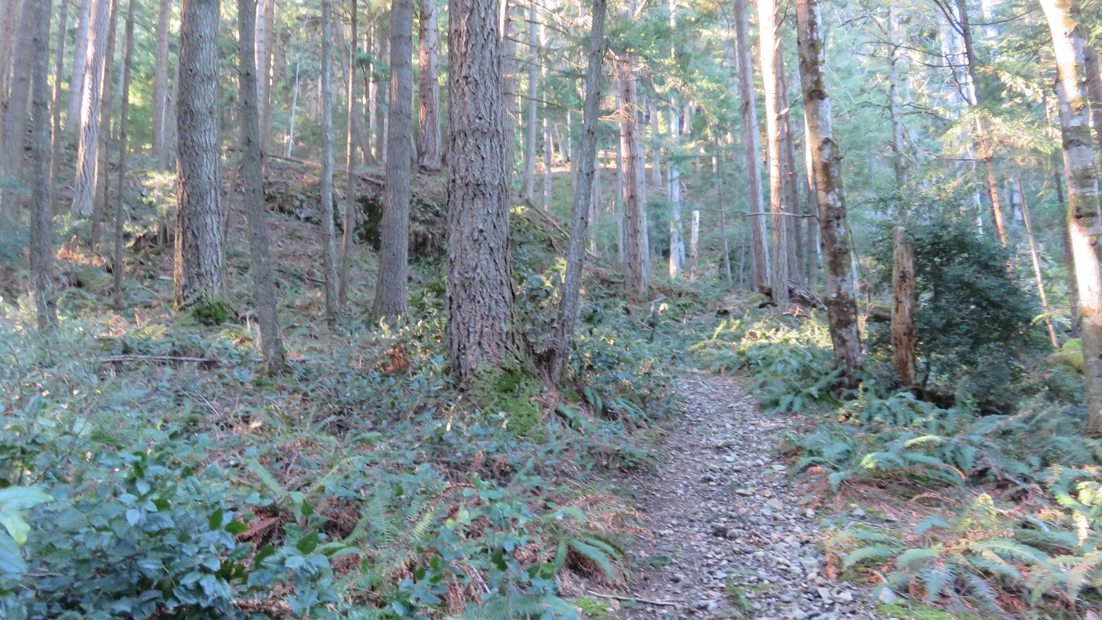
In this direction, the trail felt flat and easy, from my trip to Spain, I knew that meant I was going slightly downhill.


It was really easy to the follow trail in this direction, even though I saw no markers.


I circled the pit from far above. I didn't see any alternate trail in this direction either, making me think that the Google maps trail was simply inaccurate in this area.


After one last downhill stretch, I was at the trail intersection with the red car again. I turned left, away from the work site.


It was mostly downhill. Several times, I jogged lightly, to make sure I got back in time before dark.

I passed the fork with the log across the right-hand trail. I stayed left/straight.

This section was quite straightforward, but there was some debris.

As the trail ran along the creek, I passed the stairs to the previously mentioned mysterious building, located on the other side of the creek.


The left hand fork was definitely going in the wrong direction, according to my GPS. There were two giant stumps on the right-hand fork... I went that way, but according to my GPS, it looked like I cut off the corner of the trail where it turned (see screenshots below).


Well, if I was uptown, then I figured that "failing all else, heading downhill is good." A little later, I crossed some more downed trees.


Next was a trip down the creekbed, as the trail led straight through it. That turned into the path around Grafton Lake.


I trudged up the steep incline until I reached the fork, where I went left, but again, it didn't matter which fork I took, as they both rejoined soon enough. I was feeling more confident, as I remembered the landmarks I had passed on the way in, and it was sure nice not to have to check GPS every three feet!!


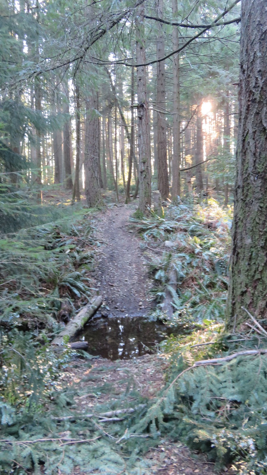
I circled around a flooded portion of the trail, and half-jogged through the dry open forest trail after that. Although I was feeling more confident, I remembered that it was always on these flat even "easy" areas that I was most likely to fall, as I let my guard down.


Then came another narrow, water filled downhill. I slowed and chose my footing more carefully.

This is where the trail basically became the creek. I arrived at the spot where the trail split off from the creek. From this direction I could see a small plastic sign on a tree. It appeared to be the same person who had made the other "trek" sign earlier. It read "Cross Island Trail," and pointed left.


Then I looked for the tiny white sign on the trail up to the left (which said "Trail to Mt Gardner"), and and took the right hand fork, following the bank of the creek.


It's not really a big deal if you were to miss this trail exit, and continue along on the creek bed itself, as soon, you would see the trail beside the creek and could hop out there. There were also another couple exits later on. Actually, since the trail just rejoins the creek bed later, you could stay on it the whole way if you like!! That might be a really nice way to go in summer, if you had the right footwear.


As I crossed the creek and left it behind, I realized why Charles' blog didn't mention the other trail at the creek crossing: it was not really visible, when walking in this direction! The correct trail was super obvious in this direction.

Climbing over the biggest mess of fallen trees of the whole hike, a squirrel ran in parallel over them with me! He distracted me a little, and I lost the trail completely. Actually, it was MUCH harder to tell where the trail was through the debris, from this direction. I only got back on track because I remembered the big stump that I had peed next to on the way in. >.<


So if this set of debris is still there when you go: Go lengthwise (parallel to the trunks) through the hemlocks, then crosswise (perpendicular to the trunks) through the alders.


Through the next set of downed hemlock, I could see the trail beyond, so there was no risk of losing the trail there. But after clambering through the deep debris, my shoes were full of twigs and my laces needed to be retied.

The next section of trail was easy. I spotted the little cabin in the woods, off to my left, as the trail curved. On the trail, across from little cabin, I saw a pink flag. Then a sign for Duncan's Hat! Then blue flags heading up the hill. How did I not see those, coming the other way??


I walked down the trail a little further, past the sign, and turned around. They were almost completely hidden behind a large stump, when walking in the other direction! Only the little pink flag was visible. So here's a tip: if you wanted to look for the Duncan's Hat trail, you would need to start looking for it on the opposite side of the trail of the cabin, when you get to the closest point to the cabin. Charles' blog described a bit about that trail. It would take me a few more months to get there myself.

A little later, I passed the intersection with the "No motorized vehicles" sign. Charles' blog said the right-hand trail was "signed as Fitness Centre," but I saw no such signage. I was really curious as to where that trail led, but again, it would take me a few months to explore it. On this day, I was too worried about beating the dusk, and just kept on straight ahead.


About equal to ropes course, two dogs, a shih-tzu and a golden, came rushing at me, barking. I put on my big ski gloves, just in case the dogs were "nippy." In the dim light, I couldn't see them well until they got right up to me, wagging and leaping happily. They were both Good Dogs. 11/10 would pat. ;) The owner smiled a greeting and exclaimed surprise to see anyone on the trail. It was true, I had not seen anyone else hiking on the trail on my entire journey.
The trail then headed downhill, and I jogged a little more. I ducked under two fallen trees.


A car passed me, near the houses, but didn't stop or say anything. The driver simply gave me a little wave.


I could see the intersection with Carter Rd up ahead. I took the right hand fork of the road. If you were heading to the ferry, you could take either fork. The left one would pass by some public washrooms (beside the Hatchery, near the BIRD and the Knick Knack Nook), so that could be handy to know. ;)

I made my way along Carter Rd to the school and the chapel. This time, I didn't take the right-hand "detour route" up to Belterra. ;)


Approaching the little bridge across Terminal Creek, I considered going back a different way, but taking same route back to Artisan Square seemed the shortest and least steep.

On the other side of the bridge, I hopped up on the trail running alongside the road, and followed it back along the "orange fence" trail.


I crossed the little plank bridge and went directly straight to the bus stop on Grafton Rd.


From there, I crossed Grafton Rd and headed up Artisan Lane.

I continued straight (left) at the intersection and soon arrived at the shops of Artisan Square.


The view of the mountains from Artisan Square was beautiful, and the ski runs twinkled at the top.

My hip started hurting on the way home from Artisan Square, but by 5:40pm I was home.
In the growing dark, I saw the moon and Venus in sky... Not Mars though, which I was also supposed to see, forming the peak of a triangle with the other two.


When I got home, I needed to sit down. I was glad for my hiking boots on the wet parts of the trail, but walking so much in them threw off my balance and made everything below my waist sore. Time to rest with some "cheese time." :D
No comments:
Post a Comment