Well, it didn't hit the predicted -11°C today, but it was close to -8°C... but with crystal clear blue skies again, a walk was definitely on the agenda! I decided to continue my previously aborted journey into Scarbourough.
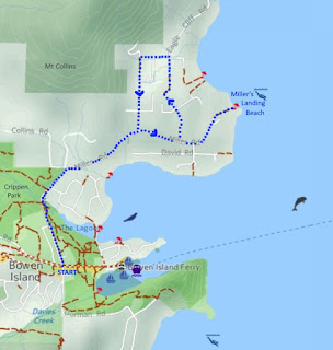
I plotted a route that would take me through some of the pedestrian right-of-way easements that I could see on bowentrails.ca. Below, I used a screenshot of their map to mark my trail (in blue), because they have the only map showing these easements (in red). In all, around 6.5km, with several quite steep sections (see details below).
(click on map to enlarge, or visit the unmarked original at bowentrails.ca)
I bundled up and headed out. After my windy day experience the day before, I opted for this lovely pink toque that tied under the chin. No wind was gonna defeat me today!!
It was so cold, it hurt my fingers to whenever I took off my gloves to text or take photos. The pavement was frozen into a solid sheet of ice. If you look carefully in the photo below, you can see the marks of a vehicle's chains, cut into the surface. Fortunately, I had decided to throw my new Yaktrax in my backpack before leaving the house.
I stuck to the walkway beside Village Square, which must have been salted, as it was free of ice.
I inched my way across the intersection to Miller Rd, and took the footpath running right beside it.
Near the emergency services centres (which I wrote about in a previous blog), there was a lot of debris from the previous day's windstorm still littering the path; however, a little farther along, the path was remarkably clear of debris. The snow shone white and gleaming.
Well, actually, what looked like snow on the path was actually a few inches of crusted ice, frozen into the footprint shapes previous walkers had left on their journeys.
Every now and then, a larger branch blocked the path, but for the most part, the walking was fairly easy, just slow. I admit that was not *only* due to the slippery conditions: I was also having a text conversation with a friend at the time, but could not text and walk at the same time on the icy path. Every time my phone alerted me with a message, I had to stop and stand still to answer, else risk a fall.
At this point, another lady caught up to me. She was also picking her steps very carefully, but didn't have the phone messages to contend with. ;) However, she was carrying a shopping bag of items she had picked up at the Village and was on her way back home. We walked together for a while. She commented that she had lost power from the storm and asked if I had as well. Thanks to the underground power lines in our area, we had not. I wondered how much of the island was affected by power loss.
Our paths diverged when she chose the forest path instead of the road, where Killarney Creek Trail left Miller Rd, near the St Gerard's Mission Catholic church on Melmore Rd. We wished each other luck, and I continued on the road past that church, and the Little Red Church at Reed Rd/Collins Rd. (I have blogged in detail about these churches previously.)
As I approached the hill up to Miller's Landing, two ravens flew over me! :D Since Raven is one of my major totem animals, their arrival could have been signaling a good omen. However, since Raven is also known as "the trickster," their cackles could also have been their way of mocking my optimistic attempt to hike up the hill on Miller Rd on this icy day.
I encountered two other ladies, walking towards me on Miller Rd. I asked them whether they had just come down the hill. "No," they replied with sheepish grins: they had started walking only on this side of the hill.
The hill was so steep! It rose about 60m in just over 0.5km. While trudging up the hill in my bundled layers, I grew too hot. Feeling nauseous, I took off my ski gloves and opened my jacket. I tried to distract myself with the peek-a-boo views of Deep Bay.
I checked the second footpath down from Miller to David, and it looked completely dry and clear. However, I was still thinking of the second stretch of David Rd, so I didn't risk it.
Where Miller Rd met Scarbourough, Miller leveled off somewhat, then started heading downhill towards Miller's Landing Beach, dropping 65m in elevation in about 850m of distance.
I passed Oceanview Rd, where I would return to continue through Scarbourough, after my stop at the beach.
I passed Ecclestone Rd, and more ravens circled overhead.
Peeking through the trees, I could see glimpses of the great view I'd have from the beach. It also made me feel like I was "almost there" for far too long. At the right of the photo below, a holly bush was busting out all over with bright red berries.
Just as I was reaching the end of the road, I heard a vehicle behind me. A public bus pulled up, then did a three-point turn on the road behind me. I guess this was the end of the bus route. No one got on or off the bus. It had to have been the C11, as the C10 serviced the other side of the island. You might be surprised to hear that these two routes were actually part of the Metro Vancouver Translink system.
As I approached the end of the road, I noticed a strange little cement "bunker" off to the left side.
The ice on the ground outside the little "bunker" made really neat formations. I tried to capture them in an "artistic" shot, but I'm not really sure it worked. My fingers were instantly too cold to futz around with it any more than I did.
At the end of the road, a sign pointed the way to the beach.
The little trail to the beach was full of surprises: a buoy rope swing, an arbutus tree knocked over in the storm, a set of stone pillars leading nowhere, and a bush filled with some kind of berry(?) that looked like popcorn.
The path ran steeply down to the beach, in the last little bit. Fortunately, it was dry of ice, although my shoes caught on the woody debris left over from the storm, and threatened to take me down.
The beach was actually fairly large, with a low tide, but it was by no means sandy.
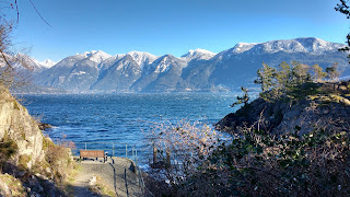
The bench overlooking the water read "In loving memory of Margaret Witty," who lived in the area for nearly a quarter century.
The view was stunning. I struggled to get panos in the biting wind. It seemed I could capture the cove, or the mountains, but not both at once.
I ended up making a "fake pano" to try to get both, but the light was very inconsistent from shot to shot. Whatever. It's "art," right? ;)
The wind kicked up waves on the little island off-shore, which sometimes housed herons or cormorants. It was so cold, I thought my fingers would break off. So much for my idyllic snack break.
I took a last look at the cove, and ended up stuffing my granola bar into my mouth as I rushed back up the path to the road.
At the cul-de-sac, a guy was leaf blowing some of the debris off of the road. Crows chased me all the way up the hill, swooping at my head and cackling from the trees, until, at the intersection with Oceanview Rd, I finally thought to pull on my green hood to cover my pink toque. That seemed to please them enough to leave me alone. I wondered who in the area wore a pink hat, and what that person had done to the crows...
(go ahead and click on the photo to zoom in and play "count the crows"!)
The map at bowentrails.ca showed a water access off Jason Rd. On the day I saw the giant buck, I had looked for this trail, and not found it. The trail was certainly not obvious, in any case. On this winter day, the road looked quite slippery, and I didn't fancy heading down there just to poke around in someone's driveway.
I really wanted to find the trail that led from Oceanview Rd to Eaglecliff Rd. At first, the path was simple enough: just past the intersection with Jason Rd, a sign declared "no thru road," and marked the end of the pavement and the start of a gravel lane.
While a couple of cars were parked just after this sign, the amount of debris on the road led me to believe that this was not a well-used lane.
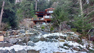
Just behind the sign, on the other side of the road, was a large blue "tree house" style platform, and behind that, one of the first houses I had fallen in love with on the island, when I first started looking buying a home here years ago. I hadn't really registered that THIS was where that house was. Back at that time, the price tag seemed too high for my budget. Little would I know, that in the future, I would dream of house prices as low as they were. Hindsight is 20/20, right? >.<
Just past that, the road curved to the right, and she pointed me to the trail. There was actually a "trail" sign there, but I had missed seeing it, until she pointed it out.
The "trail" was actually a big staircase, at this point. "It's slippery," she warned me, knitting her brow in concern. I told her that I had brought crampons in my backpack in case I got stuck. I'm sure I sounded pretty confident, because she wished me well, and left. Internally, I was less confident, but I kept reassuring to myself that I hadn't fallen on the ice since I bought my new boots.
Finally, both the web of power lines and the snow ended all at once. I turned a corner, and the rest of Oceanview Rd appeared before me. Mission Accomplished! :D
Back in the snow, I walked the last 150m or so to the intersection with Creek Rd.
I passed a Bowen landmark at the corner: The Yoga Loft. The Yoga Loft offered classes in Iyengar yoga seven days a week, led by Saskia Gould and Sarah Godfrey. By coincidence, Saskia used to own Wildwood Lane Cottages, where I used to teach Reiki workshops (I'd post a link to my fab website, but after an unintended domain-name renewal lapse, GoDaddy has my long-cherished domain name held for ransom in a warehouse for hundreds of dollars).
While I could have turned left onto Eaglecliff Rd to connect back with Scarborough Rd, bowentrails.ca showed another footpath linking Creek Rd to Scarborough Rd, so I decided to head on up Creek Rd to find it.
I followed the trail sign arrow, pointing along the wooden railing. It led across a little bridge.
After a short gravel trail, I was suddenly on Hillcrest St, in front of another house we had previously looked at buying.
Below is a photo looking back at where I just exited, up on the left. If you look closely, you can see a "trail" sign pointing left, in between the trail and the road.
I followed Hillcrest St to the next intersection, where it merged with Scarborough Rd.
I turned right onto Miller Rd, and had a laugh at this street sign aimed at heavy trucks: "Please, dead slow, no wake." Yep, definitely an ocean-front town. ;)
Soon, I was passing the Little Red Church again.
Then the Catholic church.
After reaching Melmore Rd, I picked my way slowly down the snowy path beside Miller Rd.
Arriving at the entrance to Crippen Park, I considered heading through the park, then decided to just continue along Miller Rd to the Village.
The new pub was coming along nicely, at the corner of Miller Rd and Bowen Island Trunk Rd, despite necessary breaks in construction, due to the weather. I was really looking forward to seeing it completed.
Arriving at home, I surprised Colin with cheese time. Later, he surprised me, by making shortbread cookies! We listened to the wind roar all night, and I pondered my next hike. Maybe somewhere a little less "dramatic"? ;)


