
My friend Nihan was over visiting, and we decided to go back to Quarry Park and Fairy Fen, and take a longer walk through the adjacent Crownlandia (Crown Land is owned by the BC government, and considered to be public land-- bet you didn't know that 94% of BC is Crown Land!). If you compare the two hikes, you can see that they are very nicely complementary, as far as coverage of the parks. For more info and background about the actual lands of Fairy Fen and Quarry Park, see my previous blog entry.
On this hike, we ended up wandering around for a few hours. Much of that was trying to figure out where we were at any given time. ;p In contrast to the 20-acre Quarry Park, there were many many unmarked trails in the 44-acre Fairy Fen and 395-acre Crownlandia.
As I mentioned in my last blog, google maps had zero trails showing in the whole area, so my GPS was not very helpful in helping us navigate the trails shown on the bowentrails.ca Quarry Park PDF map. We navigated the best we could, using the same screenshot of the map that I had taken last time, saved onto my phone.

Below is the best guess I have at the route we took. As you'll see, we got a little confused in a few areas. I marked the "unsure" areas with question marks.

(click to enlarge map)
Why would we get confused, you ask? Well, besides the plethora of unmarked trails mentioned earlier, particularly in the case of the nature reserve, the dotted "blue trails" on the map are designated as "deer trails." This means trails that were naturally-created by the repeated passing of deer (and humans).
According to a report for the Island Trust, "The existing trail network in the area of Radar Hill [in Crownlandia] is fairly extensive. However, one of the trails crossing the [Fairy Fen] Reserve are part of a legally dedicated or otherwise formalized trail system. Except for the former logging track, all have resulted from repeated recreational use... the number of informal trails has been increasing over the past ten years, mostly due to increasing popularity of off-road cycling and, to a lesser extent, recreation with ATVs and 4X4s [note that these are NOT encouraged in the reserve]. These user groups have made alterations, such as cutting of logs and stumps... [but] A number of the former mountain-biking trails are already disappearing as a result of disuse."
We started at the same parking lot as the previous visit, but after passing the map signage kiosk, instead of taking the right-hand trail with the "pedestrians only" posts, as we did in the last blog entry, we took the unmarked left hand trail, which led straight out of the end of the parking lot.


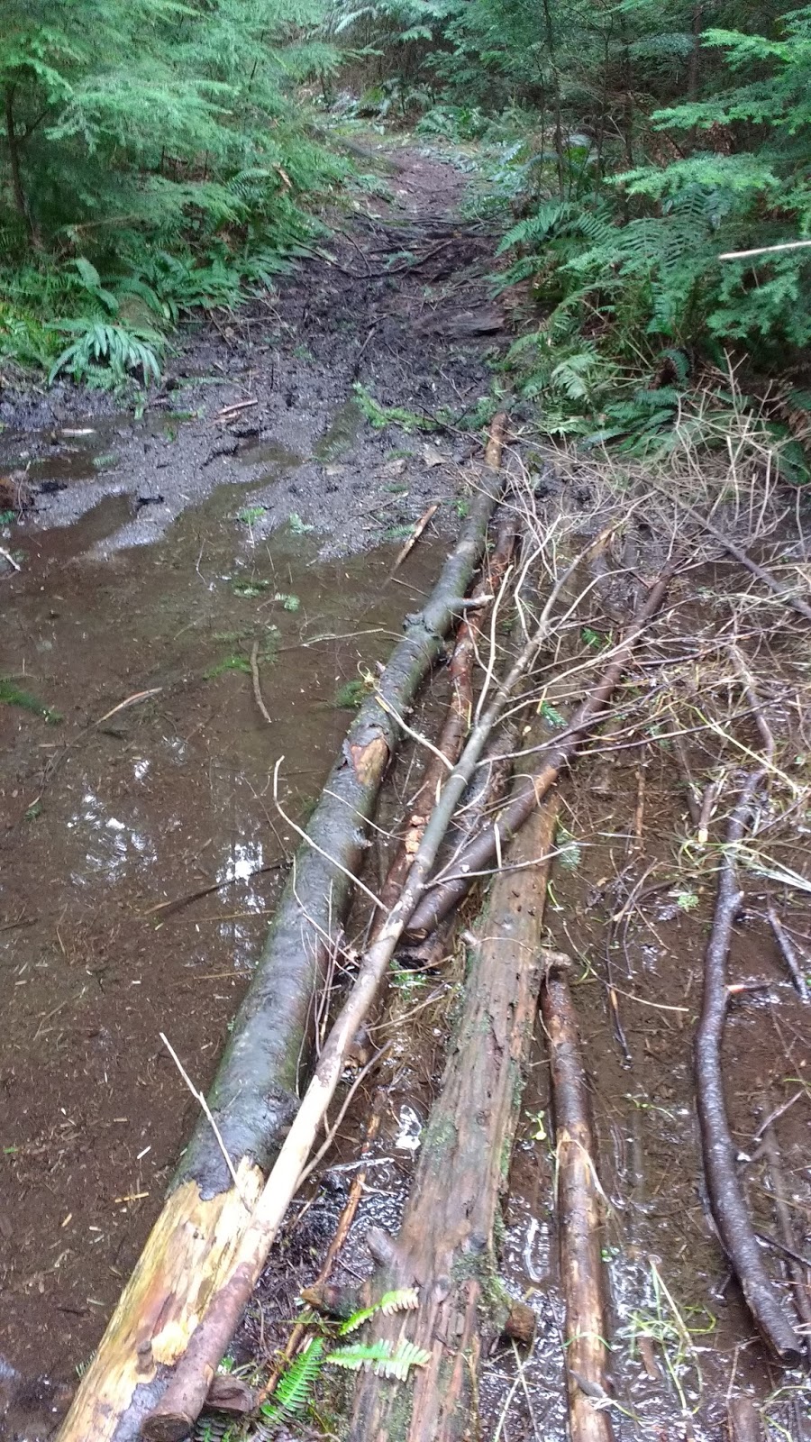
The trail narrowed, and was flooded and muddy in a few spots. At one such spot, someone had made a makeshift "bridge" over the water.

We were looking for another fork, so that we could stay right and end up on the orange trail on the map. The orange trail was marked as a "bike trail," which were normally more established than the "pedestrian only" trails, so we thought it should be fairly obvious. After passing one potential trail on the right, which seemed to disintegrate pretty quickly, we ran into this very clear T-junction. Only problem was, we were not expecting a T-junction. We wondered whether the decrepit potential trail we passed was the one we were looking for, or whether this T-junction was indeed it. We decided that either way, we should take a right turn, to go deeper into Crownlandia.

This trail was wider and well-established. The terrain varied from dirt, to rock, to grass. Tread marks in the dirt told us that this part of the trail was indeed used for biking. It all seemed like a good sign.


The grassy part of the trail offered us another fork. Consulting the map, we decided to take another right, so that no matter which trail we were actually on, we would still end up where we had planned to be, and could continue onward from there as planned.

This section of the trail was quite lovely. Some parts here were flooded too, but there were alternate routes around the flooded areas.

At one point we passed a sign for "Nero's Run," but without any context for this trail name, it didn't help us confirm anything on our map. (If you know anything about this trail name or history, please leave me a comment!!)


The trail was pretty easy to follow, so we were feeling pretty confident. We were aiming to enter the Fairy Fen Nature Reserve from this trail, then loop to the right to go lengthways through the reserve, basically following Upper Huszar Creek, and arrive at the actual "fen" from the opposite side that we had approached it on the previous trip.


The trail headed downhill, then flattened out, then downhill again, in turns.


There were a couple of spots where the trail split, but then quickly rejoined again.


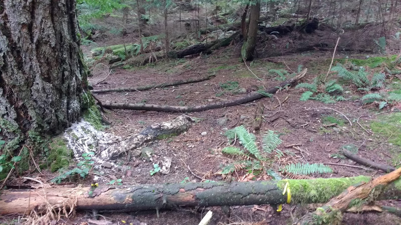
A few trees had fallen fairly recently, probably in the strong windstorms over the past few weeks, but someone had come along and sawed out the portions that blocked the trail.


A sign marked the edge of the nature reserve. So far so good! A well-established trail that led away to the left of the sign. that matched the dotted red line on the map. At least we knew we were where we had hoped to be. :) We wanted to follow the debris-strewn trail directly behind the sign, to enter the reserve proper. Raven kept crowing as we entered... did that trickster know how confusing the trails in Fairy Fen would be? ;)


From that point onward, the trail was much less clear and maintained. However, brightly colored trail flags (see bottom right of photo below) confirmed that we were on the correct trail.


Here's a little fungus we found. Looked like a slug or a manatee. :D

A little farther along, the ground sparkled strangely, covered in a twinkly blanket. "Let the magic begin!" we laughed, and crouched down to investigate. Maybe it was broken glass... but we decided it was precious jewels. ;)

Right after that, we could see two trails: one leading more or less straight ahead, and another off to the right.

After consulting the map, we took the one off to the right, thinking it would take us towards Fairy Fen proper, whereas the one to the left looked like it would soon exit the nature reserve and go back into Crownlandia.

We were happy to find an orange trail flag on the ground. It made us think we picked the correct trail.

However, we soon arrived at another sign announcing the edge of the reserve.It was facing away from us, towards the well-established trail circling the perimeter of the reserve in this area. We couldn't figure out how we had done that, based on the map.

We retraced our steps back to the broken glass... er... jewels.... er, previous fork in the trail.

We took the left fork this time. It soon dumped us out to the well-maintained perimeter trail, just a little ways down from the reserve boundary sign.


We decided to follow that trail around the corner of the reserve, and head back into the reserve on a different blue trail. At the sign, an overgrown trail led off to the left. We skirted a huge puddle on the trail right at the corner, and a second trail split off to the left. There was only one trail marked on the map at that corner. I think the first one just joined up with the second one.


We started looking for an entrance back in to the reserve on the right side of the trail. We had to climb around two very large puddles before we saw it-- marked with yet another reserve boundary sign-- right about where we thought it should be.


Feeling more confident that we were back on track, we dove in.

Right away, we passed some big rounds of wood. They almost looked set up as a makeshift picnic area.

Then we reached a fork in the trail. This was exactly the fork we had been looking for, when coming from the other direction. So we took the left fork to head towards Fairy Fen's ... um, fen.

The trail was really covered in windfalled branches, but again, we saw some trail flags --again on the ground-- to confirm that this was indeed a path (zoom in to see the flag at the ends of the two logs in the photo below).

After that, the trail was more clear. We passed another flooded section, and as we tried to skirt it on some logs, we were startled by a flash of motion in the water. It was a Northern Salamander! :D


Then we arrived at an unexpected fork. We didn't see any corresponding fork on the map. We took the left fork.

The trail took us past this interesting tree, surrounded by fallen debris.


After that, the trail cleared up again, and soon we saw another nature reserve boundary sign. What??? We didn't think we were anywhere near the park boundary-- we thought we were in the middle of the reserve! Did we already walk the entire length of the reserve?? Were we at the junction below the "F" of "Fairy" on the map?? Or was this a totally unmarked trail?


There were yellow ribbons on the logs heading towards the sign, so we went to check it out.

The trail continued past the sign, and was marked with more yellow ribbons.


Then the trail split, and a tiny rough trail led off to the right. A more established trail with a large stone embedded into it went off to the left. We took the right, and plunged into the salal.


The trail plunged steeply downward. We were happy to see several trail ribbons along the way.


The trail was pretty easy to follow, and we relaxed into the journey, taking time to admire the huge trees and "play around" a little. ;)


Suddenly, the trail all but disappeared into the moss! :o We scoured the landscape for trail flags, and found a few as we made our way downhill on the mossy rocks.

Then suddenly, we popped out onto a very well-established trail.

The trail ran along beside a creek, which we assumed to be some part of Huszar Creek. I made a mental note of the spot where we emerged from the moss, because there was no marker there.

We turned right, and followed the trail and creek.

We walked on what seemed like it used to be a boardwalk, all but rotted into the trail beneath. There was a lot of downed trees here too.


And again, quite suddenly, it seemed to us, we came across two signs announcing, "Welcome to Fairy Fen Nature Reserve." A trail flag was wrapped around a tree just past the signs, so we walked down to see if there was anything interesting there.

Um.... it was the fen proper! Looking just like it did on its website. We had almost walked right past it!

As I mentioned in my previous post, “It has taken nearly twelve thousand years to create the peat layer that now stands three meters over the lake that once stood here at Fairy Fen." And THIS sure looked peaty. There were also other plants in the Fen, such as Labrador Tea, bog St. John's-wort, and bog cranberry.
We continued onward a little ways. It appeared as if the trail ended at a small creek, but we could see another well-established trail just on the other side. We used some large fallen trees as makeshift bridges to cross two small tributary creeks that were side by side. Then I recognized the signage and stump from my last hike in Fairy Fen... and yep, the same fallen tree to the left of the clearing. Last time, we had arrived just on the other side of this small pair of creeks! We had made it so close to the fen proper, but didn't realize we would need to cross the creeks to get to it!


Very pleased to have solved that mystery, we turned around and headed back the way we had come.


Upon reaching the double signs, we turned right, back onto the main trail that followed the creek.


Reaching the point where I had previously made a mental note in my mind about the entrance to the little side trail we had taken to get here, I was so happy I had done so, because if I had not just come from this little side trail, and paid attention to where it was, I would never have found it!!

There it is, on the left in the photo below. Nothing. >.<

We headed upward towards the moss. There were some tiny hints that the trail was there, like small fallen logs that had been cut with a saw. But only a careful eye could catch those. On my various hikes on Bowen Island, I had found the cut branches and logs to be one of the most useful "signs" of a trail. Sometimes they were the ONLY sign that the trail ran through a certain area.

Once we reached the moss, a trace of a trail began to appear and led us uphill to the left. However, here, some of the fallen logs were NOT cut (can't win 'em all). On the other hand, some still were, and were very reassuring.


Eventually, we saw a blue trail flag, hanging from a tree.

We followed the trail into the woods, and from there on, there were more blue flags.


We headed back up the steepest part of the trail. From this direction, it certainly seemed like there were more flags visible than when we came down in the opposite direction. I guess some were hidden from view, behind debris.


Then we were back on the salal-ridden trail, and we turned left back onto the grassy trail at the top of the hill.


The grassy trail led us back to the signage at the edge of the reserve.


We passed the sign and retraced our steps past the yellow trail flags. (Note that there were actually two routes behind the sign. They rejoined pretty quickly.)
We turned left after the yellow flags, and headed back to the weird tree near all the fallen trees. This part was a little confusing, because from this direction, it looked like the majority of the debris was actually blocking the original trail, on the left, and we had to take a small side-trail on the right to get back to the tree. We hadn't even seen the other trail on the way in.


Fortunately, it was a very recognizable tree, and we could see it at a distance, off to the left.


Past the tree, we made a little jaunt past the pool where we had seen the salamander. It turned out that we could have taken a dry detour path on the right, instead of balancing on logs past the pool of water. So we did that on the way back.

It quickly rejoined the same path, on the other side of the pond.


We were approaching our right-hand turn, but we didn't recognize it, and took the left hand fork at the junction. We had only gone a few steps, when I stopped us: "This isn't right!" We turned around and walked back to the junction. Seeing the flags at the end of the two cut logs on the ground, I realized we had to head right instead.


We again passed the cut rounds of woods, and exited past the nature reserve boundary sign back onto the red trail that rounded the corner outside of the reserve.

We crossed back over the two large flooded areas.


At the corner, I wanted to explore the figure 8 shaped loops off to the right, but Nihan wanted to head straight back. So we decided to take the most direct route north to the parking lot.


Past the sign there were several more large pools of water on the trail to navigate around.

Then the trail got very clear and wide. We passed a + shaped intersection, where a trail led off to the left and another to the right (hard to capture in one photo, even on pano). We figured that we were just past the top right (north east) corner of the Fairy Fen Nature Reserve.


There were some signs on the right-hand trail, and I ran down to see. They were not very informative.


I ran back to the intersection and we continued straight ahead.

We were looking for a trail that went off to the left, then we wanted to stay right, then go left, to get back to the parking lot. We figured that this was the first turn, and stayed left.

We climbed sharply uphill on a rocky trail. At the top of the hill was a blue garbage can. :o Who carried that way out here??


Then there was another steep rocky uphill. Along it was a root that looked to me like a piece of art.


At the next junction, we wanted to stay right. Everything seemed to be going as planned.


A strange blobby tree revealed itself to be a giant tire that someone had somehow managed to lower onto the tree. Or was the tire there BEFORE the tree?? Was it one of the rare Ficus Elastica I had been hearing about, just growing here in the wild??


At the next junction, we wanted to go left, but the left hand trail seemed to disintegrate very quickly into a debris pile. There was even a canpoy rusting away in the underbrush. Apparently, people do come into Crown Land to harvest firewood, and this legal, as long as you have a permit.


A tiny vestige of a trail seemed light it MIGHT lead onward past the debris, but it barely looked like a trail. So we decided we'd go back and continue on the right-hand fork. It would take us to Cowan Point Rd, not far from the parking lot. Or so we thought....

We ducked under a very large downed tree that was across the trail.


And ended up on a gravel road, surprisingly busy with large dump trucks!! :o "How did we get here??" we wondered. According to the map, we must have been on the gravel road leading to/from the Quarry!

My phone camera died at this point, and Nihan took a few photos to complete the walk. Here's a passing flatbed truck.

We turned left onto the gravel road. If we were correct, and on the Quarry Road, then we should arrive on Cowan Point Rd just on the other side of Josephine Dr.

Yep, that's exactly where we were! We couldn't figure out how we had gotten there. We must have taken a right instead of a left, after leaving the reserve?? But then, what were the other junctions we had passed? They were not on the map.

We passed a flooded out trail on the left side of the road, almost obscured with low-hanging branches. I wished I had taken a photo of it, because I wondered, "Was THAT the trail we were aiming for?" If so, I was glad we never found it.
After about 500m on the road, we were back at the entrance to the parking lot to Quarry Park.
