
After three days off hiking to rest my poor rib, searching the internet to discover there is nothing doctors can do for a broken rib (they don't even wrap broken ribs anymore, for fear of pneumonia!), ensuring I don't have anything really serious (like flail chest), and rearranging my bed to
create a mountain of pillows for my legs that would take the pressure off my
back, I’m finally feeling better enough for a short randonnée. I pop another extra-strength Advil, fill my pockets with the daily dose limit, and plot a route.
We decide to drive to Sainte Paule, and do a circular route of about 3km,
with the option of adding on another 1.5km at the end, depending on how I feel.
The 3km route has a 250m drop in elevation to the creek, then another 250m back up. The extra 1.5km would add another 80m up and 75m down.

We park at the Sainte Paule cemetery.
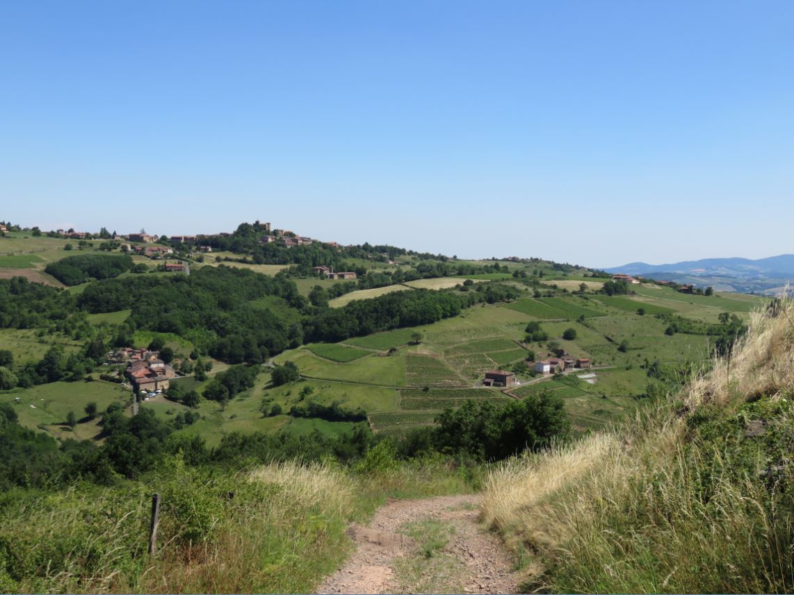
The view from the parking lot is amazing!! We stand there a good long
while, taking photos. I notice a church
perched all alone on a ridge. It seems
like a great destination hike, and I mentally start planning my next hike there.


The trail starts on the opposite side of the cemetery from the parking
lot. There is a yellow randonnée
signpost pointing us South towards Le Vervuis.


We walk along the length of the cemetery until the pavement turns to
gravel. There, the path starts plunging
downward at an alarming rate. We can see Oingt ahead of us, perched on the top of a hill. It really doesn’t look very far away. We plan to return to this area and do a walk
that includes Oingt, which is on the list of “the most beautiful villages of
France.” Maybe we can do Oingt and that church I saw in the same randonnée.

It seems like this path is still actively being used by vignerons, who
are working in the vineyards today as we descend.

To my right, I can see the path I think we will take on our return from Le
Vervius. It seems less steep than the path
we are currently on. Our path turns to
grass we pass through vineyard after vineyard.


Closer to Le Vervuis, the path returns to rock, but here it is
extremely rough and creviced, as if ravaged by water runoff. At the Vervius signpost, we practically do a
U-turn and head back up the rocky path towards Lambert.
We’re a little disappointed that we don’t actually get to see the Vervius
creek that runs along this valley.


Heading back through the woods, we hit a fork, and I notice a spray
painted red arrow pointing us on the obvious rocky path straight ahead (where
Colin is standing). But Colin checks the
GPS, and decides that the correct path up to Lambert is actually the grassy path to the
right. We head up the grassy path. It has wheel ruts so deep, we can’t figure
out what kind of vehicle wouldn’t bottom out on this road. Looking at the randonnée map afterwards, I think the "correct path" was the rocky one after all, but in the end, both lead to Lambert, so it really doesn't matter.


Soon, we are up on the ridge I could see from our path down. I pant:
“Did I say this was the LESS steep route?”

At the top of the hill, we find ourselves in Lambert le Bas, which yields
seamlessly into Lambert le Haut. The
houses are very picturesque.


Soon we are at the Lambert le Haut signpost. We decide to tack on the extra 1.5km to the summit
of Cret de la Garde, but then instead of heading for Les Avenières, which would
take us up to Cret de la Garde, we mistakenly head towards Haut du Bourg and
the Cemetery.


As we enter the town, we
notice the stones are much more “pink” here, rather than “golden.” Colin muses: “I wonder how many places in
France are called Saint Paul? Wasn’t he
pretty important to Christianity?”

We pass the church of Sainte Paule, whose plaque answers Colin’s
question: “Welcome to Sainte Paule. We
are the only commune in France with this name.”
The French language portion of the sign includes additional info: “A
commune with this same name is situated in Canada.” Huh. Go
figure. Plus, the sign specifies that this particular Sainte Paule was a Roman woman who died in Bethlehem in 404. Not the same Saint Paul we assumed. I guess the e’s on both Sainte and Paule should
have tipped us off. The sign indicates
this church is 11-12th century, with a 17th century statue
of Sainte Paule inside. To our great
fortune, the doors of the church are open and we can look inside!


The cross outside the church shows an image of the Virgin Mary with angels (in the middle) and Saint James de Compostela blessing a pilgrim (on the base). The Saint James imagery is an exciting feature for me, because The Way of Saint James is one of my dream hikes. I had originally planned to do the first 100km or so from Le Puy on this three month sejourn to France, but very poor weather caused us to delay from the original dates we had planned in May, then 29 days of visiting friends and family delayed a June reschedule. Now almost July, with our week-long trip to England looming, I don't think we will have the opportunity to reschedule the Le Puy hike on this sejourn. I'm sad about that, but I also feel better about it than I would have predicted, because I have still had the opportunity to randonnée almost every single day, in some pretty amazing countryside. :D

As we approach the camionnette, parked by the cemetery of Sainte Paule, I feel very happy with today’s randonnée. My rib seems ok (woohoo!!) and the scenery in this area is truly lovely. I can’t wait to explore it more tomorrow. :D
No comments:
Post a Comment