
Colin urges me to give it up already, but I just can't seem to understand how we could not find the path along the creek to La Burie. Looking at it from Le Crèt, the path seems clearly visible. How could we have missed it??
Colin is certain the path doesn't exist, even though googlemaps is insistent that it does. "We were there--there is no path! There's just a fence." His words echo in the recesses of my mind. I can't let it go.
I grimace at the field and its invisible path: "I shall have you!" Colin shakes his head and trudges on towards Le Grand Bola.
Today's randonnée destination is La Chapelle de la Salette. Hiking on the various hills between Chamelet and Létra over the last few days, we have been eyeing the mysterious Chapelle (church), sitting completely isolated on a wooded hill on the other side of the River Azergues.

Alban had mentioned it might be open on Sundays for mass, so we figured this would be the perfect day to trek over to it. The route runs generally downhill (about 250m elevation change) about 4 km from our gite, past Le Grand Bola (see "Word of the day: Randonnée"), through La Burie (see "Létra at Last"), then South to Le Pont. From there, it crosses the River Azergues, and runs steeply uphill about 1.5 km to La Chapelle de la Salette (about 130m elevation change). The total route should be about 11 km, round trip.

The road to La Burie is fairly uneventful. In La Burie, we take the road past the little frog and koi pond, then drop off it onto the grassy path down to Le Durand, which is a little hamlet perhaps smaller than La Burie (yep, that's "the path" shown below, off the left side of the road).


Despite its small size, Le Durand has a surprising number of barking dogs tied up in tiny yards. We notice their friendliness seems inversely correlated to the length of their leash. Poor things. The lower part of Le Durand is perched right on the highway (D385) that runs through the valley parallel to the River Azergues. We can't avoid walking in the bike lane on the highway for about 200m before we see a sign on the left hand side of the road with "N.D. La Salette" pointing to what appears to be an onramp on the right side of the road. We dash across the highway, and the ramp takes us past a gorgeous little man-made forest with a horse ring.


We cross a stone walking bridge over L'Azergues into Au Pont, and follow the signage over the railroad tracks and up the hill. Although it is a steep climb, I am rewarded with my first clear view and photos of Les Bruyères, back near Létra. La Burie and Le Badier can be seen on the hills behind it, on the left and right, respectively.


Actually, the views are spectacular, and we can see everything from Roanne (55km to the West) to the iconic tower of Oingt, 10km to the East (shown below).

As we get closer to La Chapelle, we pass a number of walkers and even a pair of horse-riders, which we take as a good sign that the church will indeed be open today for mass. It is not. We circle the building, and take one spectacular photo through the peephole in the door.


The blissful-faced statues in the yard are very realistic, and remind me a little too much of the Weeping Angels in Dr. Who... I am afraid to blink or turn away, lest they suddenly attack. One is even holding a bouquet of broom, as if he were wandering around on the hillside a moment before we arrived.


After admiring the views, we head back down to the River Azergues. Even though Au Pont advertises two wineries, in the two weeks we have been in France, we have yet to pass a single winery that has been open, so we decide to leave it for today, and head back to Le Durand and La Burie. At La Burie, we head for our usual path up to Le Grand Bola, but at the intersection, Colin pauses. Our familiar path is to the right, where we saw the sheep grazing on our first visit here. "Where does this other path lead?" he asks me. I have no idea. "HERE maps" to the rescue. It tells us it is the other end of one of the paths along Ruisseau de la Grenouillère. My white whale!!!! I can't resist. "Allons-y!!!!" I cry, before Colin can refuse.

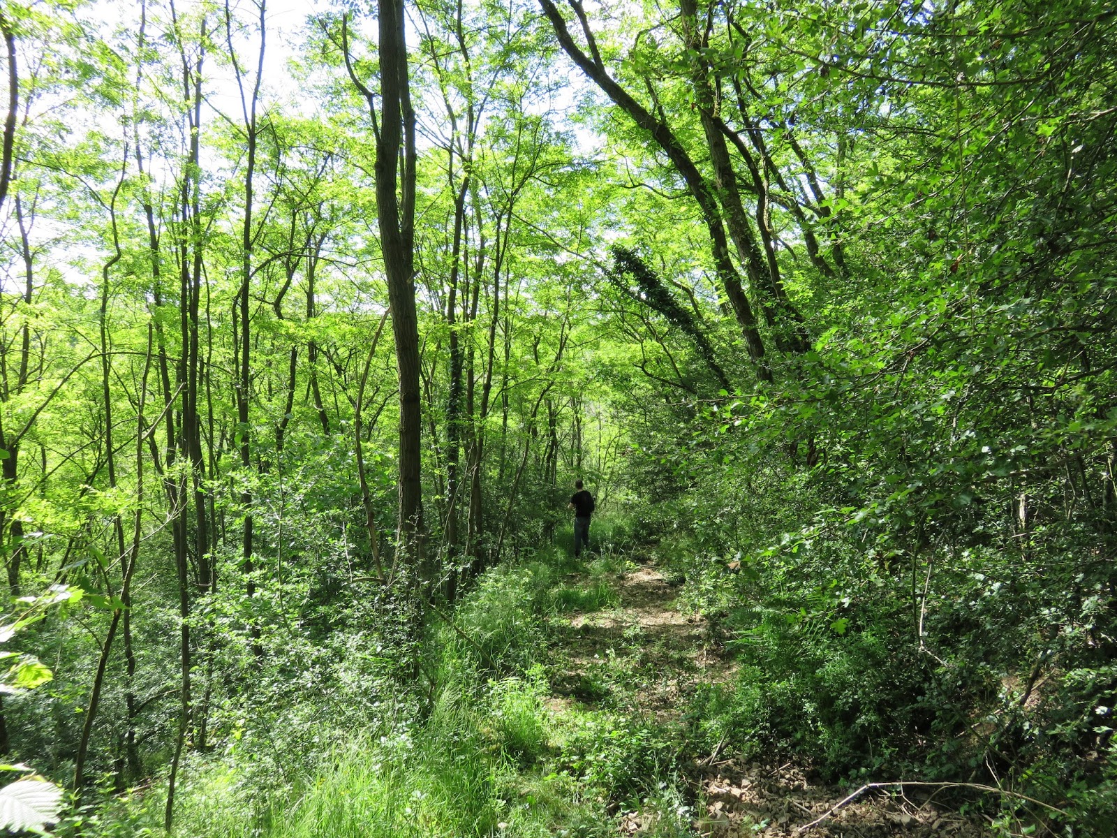
The path starts out shady and breezy, under a light canopy of trees, which is a welcome relief from the hot sun. The weather forecast says it's 22 degrees Celsius today, but it feels much hotter than that, so the shade and breeze feel heavenly. Soon we are out in the open air again. This path is definitely one of the paths that we could see from Le Crèt. We can even see Le Crèt up on the hill to the left. I have high hopes this path will lead us to the small field we got trapped in before, and somehow vindicate our past creek-mud-splashing-field-tromping-cowpie-stomping-Colin-cussing experience.

However, the path soon disintegrates into waist-high grass we must bat our way through. I can feel Colin's raised eyebrow boring into my back, but I lead on. The situation is win-win now: either I win by finding the missing trail, completing our trek along La Grenouillère, or I absolve my previous "trail fail" by confirming that there is no trail to be found. "If this doesn't work out, at least it is fairly flat back to La Burie!" I call over my shoulder. There are cows at a small watering hole next to the path. They don't seem impressed with our presence.


Eventually, we approach a wooded portion, and the underbrush gets more dense. We must be near the little field. We will soon know the truth of the matter! But the path does not lead to the left, as we expect. In fact, it soon turns to the right. Then it appears to split into five directions, each one petering out within a few yards. Confused, we try to check "HERE maps" to ascertain our relative position to the correct trail. It confirms there should be a trail heading to the left. We trace and retrace our steps. We use the GPS and stand where the trail should be. There is simply no trail heading to the left. There is no trail to the field.
Before admitting defeat and turning back to La Burie, we decide to actually try a few of the trails from the confusing intersection, in the hopes that they only *appear* to peter out, but actually lead somewhere. They do not. We finally try the one that is almost completely blocked by a fallen tree. According to "HERE maps," this path will take us around the East side of the little field, then connect us back to the path to Le Grand Bola. We decide to go for it, rather than backtracking all the way to La Burie. However, after we clamber over the fallen tree, this path also quickly disintegrates into a mess of overgrown brush.

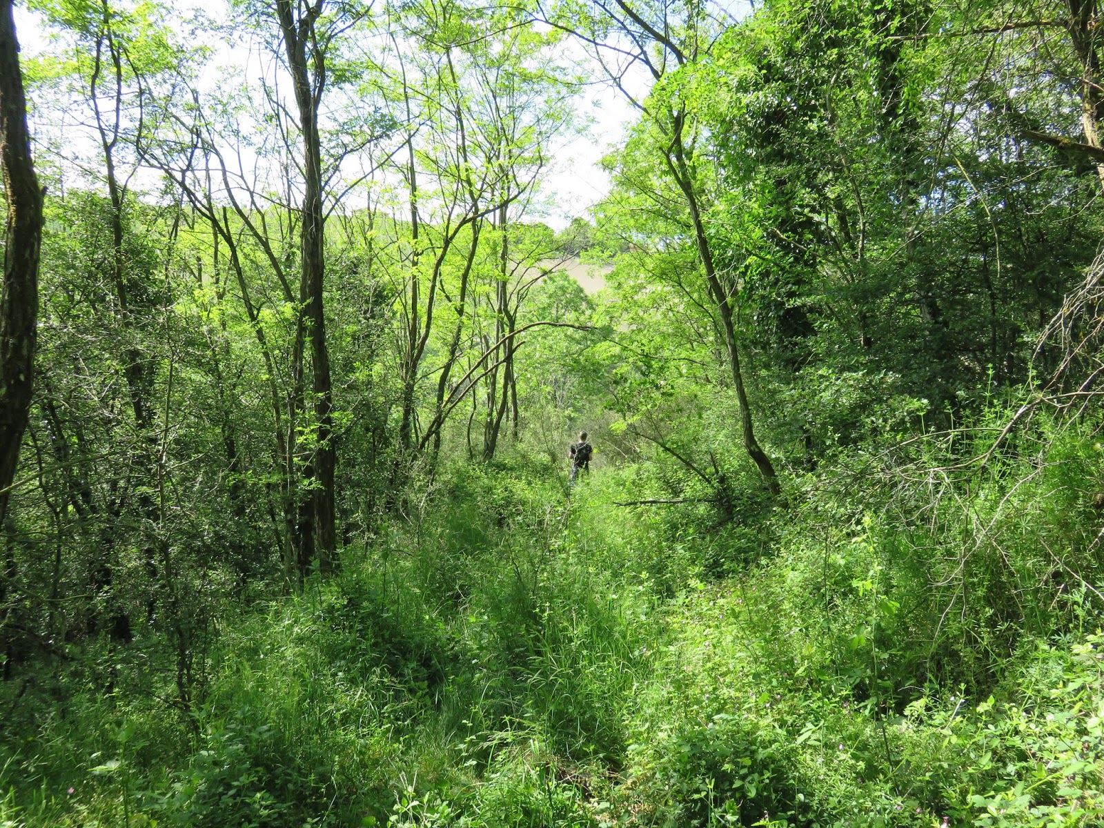
Just when we start to feel defeated... a surprising turn of events! We are suddenly standing facing the small field... one thin wire fence between us! We step over, and see the horse tracks and sneaker tracks I had found on our previous trek there!! (For those of you wanting to walk this trail in the opposite direction, I also took a photo from the field looking towards the path we just came from. The access is about half way up the South end of the field. In the photo, the break in the brush seems obvious, and it even seems like you can see a trail on the other side, but I can tell you, standing there, it is not clear that there is any trail on the other side of the fence.)


Emerging from the brush into the open field, I feel completely victorious. In celebration, I Laura Ingalls the crap out of that field!!

It feels like the birds and the frogs are celebrating with us, and we "cuckoo," whistle, and "krrrrrooooik" back at them gleefully. When we get to the creek crossing, I hug the far-most left side of the trail and am rewarded with dry, mudless shoes. Colin tries the right side and doesn't fare quite as well. (In the photo below, you can see the main path curving to the left across the creek--which is not visible until you step into it--and near the centre-right of the photo you can see a bit of the grey dirt animal trail we used as a cut-through last time).

The path after the creek is wide and open, and we ascend easily to Le Crèt. Word of my grand success spreads quickly, and as we arrive at Rue Le Cocon, I receive a full formation four-cow salute. As the John Williams music swells in my mind, I stride by proudly, "Thank you, thank you all for your support! I know some of you had your doubts..." ;)

Again, great blog and pictures. A person can get a good sense of the ''forces" that shaped you - determination, stick-to-it-ness, a love of nature, and a sense of joy.
ReplyDeleteAdd Colin to the mix - wonderful support system, wicked sense of humour, common sense who can figure things out logically, and you two are a team to be reckoned with.